You are here: Home > Network List > AK - Alaska Regional Network Stations List
> Station ATKA Atka Island Broadband > Earthquake Result Viewer
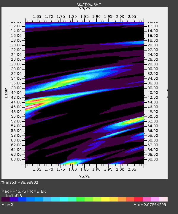
ATKA Atka Island Broadband - Earthquake Result Viewer
| Earthquake location: |
Kermadec Islands Region |
| Earthquake latitude/longitude: |
-28.0/-176.4 |
| Earthquake time(UTC): |
2016/07/13 (195) 12:11:13 GMT |
| Earthquake Depth: |
12 km |
| Earthquake Magnitude: |
6.3 MWB |
| Earthquake Catalog/Contributor: |
NEIC PDE/NEIC COMCAT |
|
| Network: |
AK Alaska Regional Network |
| Station: |
ATKA Atka Island Broadband |
| Lat/Lon: |
52.20 N/174.20 W |
| Elevation: |
55 m |
|
| Distance: |
79.9 deg |
| Az: |
1.369 deg |
| Baz: |
181.967 deg |
| Ray Param: |
0.048631296 |
| Estimated Moho Depth: |
45.75 km |
| Estimated Crust Vp/Vs: |
1.62 |
| Assumed Crust Vp: |
5.88 km/s |
| Estimated Crust Vs: |
3.641 km/s |
| Estimated Crust Poisson's Ratio: |
0.19 |
|
| Radial Match: |
88.98962 % |
| Radial Bump: |
360 |
| Transverse Match: |
70.89162 % |
| Transverse Bump: |
400 |
| SOD ConfigId: |
11737051 |
| Insert Time: |
2019-04-25 02:00:39.450 +0000 |
| GWidth: |
2.5 |
| Max Bumps: |
400 |
| Tol: |
0.001 |
|

Signal To Noise
| Channel | StoN | STA | LTA |
| AK:ATKA: :BHZ:20160713T12:22:49.907996Z | 18.878328 | 3.0855826E-6 | 1.6344576E-7 |
| AK:ATKA: :BHN:20160713T12:22:49.907996Z | 4.6220994 | 1.2780531E-6 | 2.7650924E-7 |
| AK:ATKA: :BHE:20160713T12:22:49.907996Z | 1.3869725 | 2.6373644E-7 | 1.901526E-7 |
| Arrivals |
| Ps | 4.9 SECOND |
| PpPs | 20 SECOND |
| PsPs/PpSs | 25 SECOND |


