You are here: Home > Network List > AV - Alaska Volcano Observatory Stations List
> Station AKSA Akutan Strait, Akutan Volcano, Alaska > Earthquake Result Viewer
AKSA Akutan Strait, Akutan Volcano, Alaska - Earthquake Result Viewer
| Earthquake location: |
Kermadec Islands Region |
| Earthquake latitude/longitude: |
-28.0/-176.4 |
| Earthquake time(UTC): |
2016/07/13 (195) 12:11:13 GMT |
| Earthquake Depth: |
12 km |
| Earthquake Magnitude: |
6.3 MWB |
| Earthquake Catalog/Contributor: |
NEIC PDE/NEIC COMCAT |
|
| Network: |
AV Alaska Volcano Observatory |
| Station: |
AKSA Akutan Strait, Akutan Volcano, Alaska |
| Lat/Lon: |
54.11 N/165.70 W |
| Elevation: |
213 m |
|
| Distance: |
82.3 deg |
| Az: |
6.326 deg |
| Baz: |
189.522 deg |
| Ray Param: |
0.046963274 |
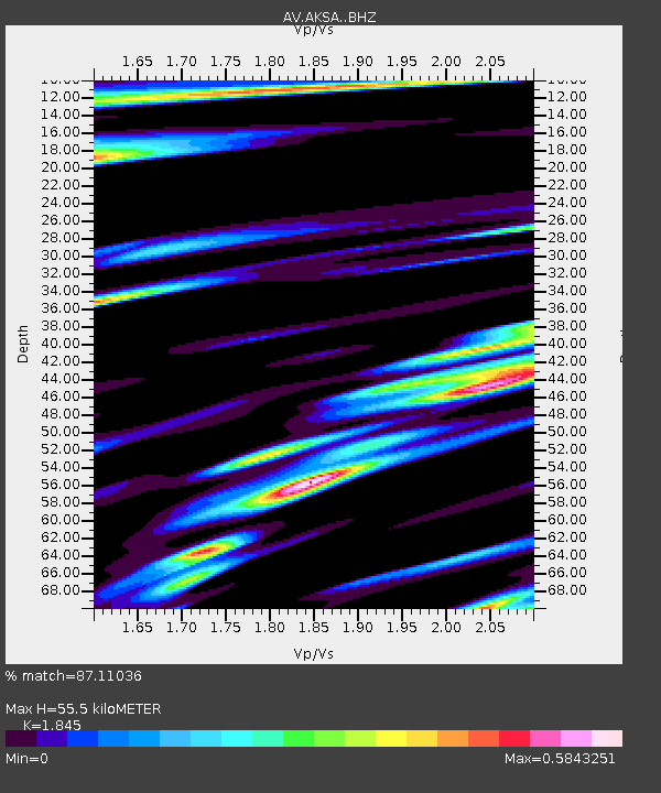
| Estimated Moho Depth: |
55.5 km |
| Estimated Crust Vp/Vs: |
1.85 |
| Assumed Crust Vp: |
5.989 km/s |
| Estimated Crust Vs: |
3.246 km/s |
| Estimated Crust Poisson's Ratio: |
0.29 |
|
| Radial Match: |
87.11036 % |
| Radial Bump: |
400 |
| Transverse Match: |
57.49609 % |
| Transverse Bump: |
400 |
| SOD ConfigId: |
11737051 |
| Insert Time: |
2019-04-25 02:02:22.904 +0000 |
| GWidth: |
2.5 |
| Max Bumps: |
400 |
| Tol: |
0.001 |
|

Signal To Noise
| Channel | StoN | STA | LTA |
| AV:AKSA: :BHZ:20160713T12:23:02.71897Z | 4.18838 | 2.729484E-6 | 6.5168024E-7 |
| AV:AKSA: :BHN:20160713T12:23:02.71897Z | 3.1689935 | 1.0712962E-6 | 3.3805568E-7 |
| AV:AKSA: :BHE:20160713T12:23:02.71897Z | 0.907792 | 6.1158715E-7 | 6.737085E-7 |
| Arrivals |
| Ps | 8.0 SECOND |
| PpPs | 26 SECOND |
| PsPs/PpSs | 34 SECOND |


