You are here: Home > Network List > KS - Korea National Seismograph Network- KMA Stations List
> Station CHJ2 Chungju, South Korea > Earthquake Result Viewer
CHJ2 Chungju, South Korea - Earthquake Result Viewer
| Earthquake location: |
Kermadec Islands Region |
| Earthquake latitude/longitude: |
-28.0/-176.4 |
| Earthquake time(UTC): |
2016/07/13 (195) 12:11:13 GMT |
| Earthquake Depth: |
12 km |
| Earthquake Magnitude: |
6.3 MWB |
| Earthquake Catalog/Contributor: |
NEIC PDE/NEIC COMCAT |
|
| Network: |
KS Korea National Seismograph Network- KMA |
| Station: |
CHJ2 Chungju, South Korea |
| Lat/Lon: |
36.87 N/127.97 E |
| Elevation: |
217 m |
|
| Distance: |
83.1 deg |
| Az: |
318.176 deg |
| Baz: |
132.684 deg |
| Ray Param: |
0.046448022 |
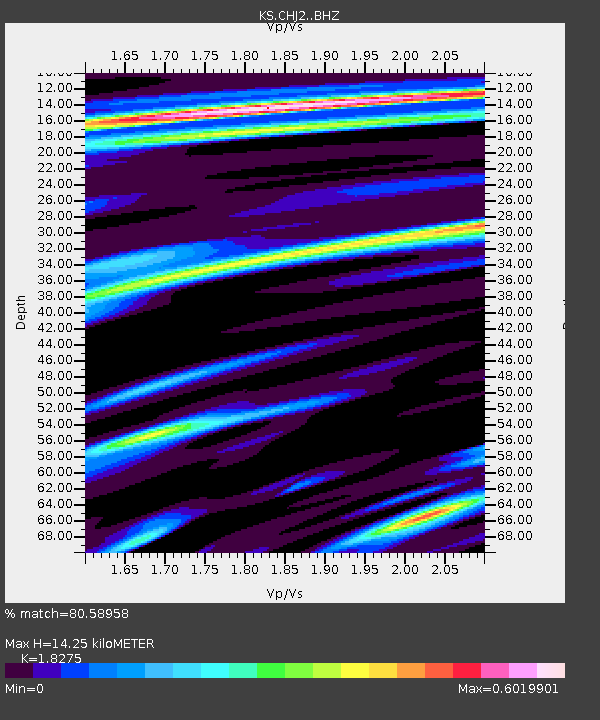
| Estimated Moho Depth: |
14.25 km |
| Estimated Crust Vp/Vs: |
1.83 |
| Assumed Crust Vp: |
6.459 km/s |
| Estimated Crust Vs: |
3.535 km/s |
| Estimated Crust Poisson's Ratio: |
0.29 |
|
| Radial Match: |
80.58958 % |
| Radial Bump: |
400 |
| Transverse Match: |
67.33071 % |
| Transverse Bump: |
400 |
| SOD ConfigId: |
11737051 |
| Insert Time: |
2019-04-25 02:05:18.637 +0000 |
| GWidth: |
2.5 |
| Max Bumps: |
400 |
| Tol: |
0.001 |
|

Signal To Noise
| Channel | StoN | STA | LTA |
| KS:CHJ2: :BHZ:20160713T12:23:06.418982Z | 6.31163 | 2.6037899E-6 | 4.125384E-7 |
| KS:CHJ2: :BHN:20160713T12:23:06.418982Z | 2.3637452 | 7.7385585E-7 | 3.2738546E-7 |
| KS:CHJ2: :BHE:20160713T12:23:06.418982Z | 3.216875 | 6.0945155E-7 | 1.8945452E-7 |
| Arrivals |
| Ps | 1.9 SECOND |
| PpPs | 6.1 SECOND |
| PsPs/PpSs | 8.0 SECOND |


