You are here: Home > Network List > NN - Western Great Basin/Eastern Sierra Nevada Stations List
> Station QSM Queen of Sheba Mine, CA. (GPS 01/17/2001) w84gm > Earthquake Result Viewer
QSM Queen of Sheba Mine, CA. (GPS 01/17/2001) w84gm - Earthquake Result Viewer
| Earthquake location: |
Kermadec Islands Region |
| Earthquake latitude/longitude: |
-28.0/-176.4 |
| Earthquake time(UTC): |
2016/07/13 (195) 12:11:13 GMT |
| Earthquake Depth: |
12 km |
| Earthquake Magnitude: |
6.3 MWB |
| Earthquake Catalog/Contributor: |
NEIC PDE/NEIC COMCAT |
|
| Network: |
NN Western Great Basin/Eastern Sierra Nevada |
| Station: |
QSM Queen of Sheba Mine, CA. (GPS 01/17/2001) w84gm |
| Lat/Lon: |
35.97 N/116.87 W |
| Elevation: |
385 m |
|
| Distance: |
84.8 deg |
| Az: |
44.587 deg |
| Baz: |
229.901 deg |
| Ray Param: |
0.045210093 |
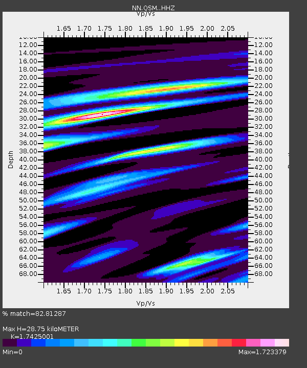
| Estimated Moho Depth: |
28.75 km |
| Estimated Crust Vp/Vs: |
1.74 |
| Assumed Crust Vp: |
6.276 km/s |
| Estimated Crust Vs: |
3.602 km/s |
| Estimated Crust Poisson's Ratio: |
0.25 |
|
| Radial Match: |
82.81287 % |
| Radial Bump: |
400 |
| Transverse Match: |
56.04924 % |
| Transverse Bump: |
400 |
| SOD ConfigId: |
11737051 |
| Insert Time: |
2019-04-25 02:05:45.173 +0000 |
| GWidth: |
2.5 |
| Max Bumps: |
400 |
| Tol: |
0.001 |
|

Signal To Noise
| Channel | StoN | STA | LTA |
| NN:QSM: :HHZ:20160713T12:23:15.628027Z | 2.552856 | 4.4205945E-7 | 1.731627E-7 |
| NN:QSM: :HHN:20160713T12:23:15.628027Z | 0.90025693 | 1.3657214E-7 | 1.517035E-7 |
| NN:QSM: :HHE:20160713T12:23:15.628027Z | 2.3428257 | 4.499245E-7 | 1.9204353E-7 |
| Arrivals |
| Ps | 3.5 SECOND |
| PpPs | 12 SECOND |
| PsPs/PpSs | 16 SECOND |


