You are here: Home > Network List > TA - USArray Transportable Network (new EarthScope stations) Stations List
> Station J04D Umpqua National Forest, Toketee, OR, USA > Earthquake Result Viewer
J04D Umpqua National Forest, Toketee, OR, USA - Earthquake Result Viewer
| Earthquake location: |
Kermadec Islands Region |
| Earthquake latitude/longitude: |
-28.0/-176.4 |
| Earthquake time(UTC): |
2016/07/13 (195) 12:11:13 GMT |
| Earthquake Depth: |
12 km |
| Earthquake Magnitude: |
6.3 MWB |
| Earthquake Catalog/Contributor: |
NEIC PDE/NEIC COMCAT |
|
| Network: |
TA USArray Transportable Network (new EarthScope stations) |
| Station: |
J04D Umpqua National Forest, Toketee, OR, USA |
| Lat/Lon: |
43.24 N/122.11 W |
| Elevation: |
1948 m |
|
| Distance: |
86.7 deg |
| Az: |
36.461 deg |
| Baz: |
225.961 deg |
| Ray Param: |
0.04387703 |
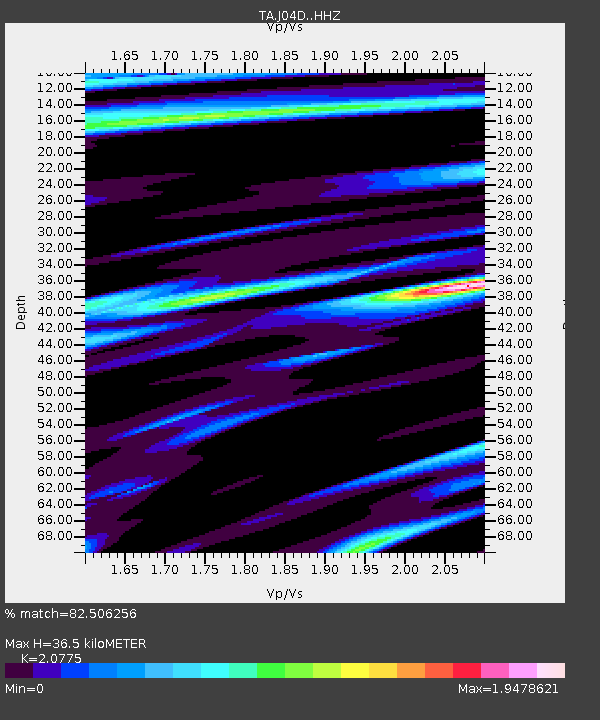
| Estimated Moho Depth: |
36.5 km |
| Estimated Crust Vp/Vs: |
2.08 |
| Assumed Crust Vp: |
6.522 km/s |
| Estimated Crust Vs: |
3.139 km/s |
| Estimated Crust Poisson's Ratio: |
0.35 |
|
| Radial Match: |
82.506256 % |
| Radial Bump: |
400 |
| Transverse Match: |
72.93249 % |
| Transverse Bump: |
400 |
| SOD ConfigId: |
11737051 |
| Insert Time: |
2019-04-25 02:07:05.615 +0000 |
| GWidth: |
2.5 |
| Max Bumps: |
400 |
| Tol: |
0.001 |
|

Signal To Noise
| Channel | StoN | STA | LTA |
| TA:J04D: :HHZ:20160713T12:23:24.790015Z | 4.520804 | 8.9571273E-7 | 1.9813129E-7 |
| TA:J04D: :HHN:20160713T12:23:24.790015Z | 1.2471484 | 4.4345407E-7 | 3.5557443E-7 |
| TA:J04D: :HHE:20160713T12:23:24.790015Z | 1.036636 | 3.04763E-7 | 2.939923E-7 |
| Arrivals |
| Ps | 6.2 SECOND |
| PpPs | 17 SECOND |
| PsPs/PpSs | 23 SECOND |


