You are here: Home > Network List > TA - USArray Transportable Network (new EarthScope stations) Stations List
> Station TPFO Pinon Flats, CA, USA > Earthquake Result Viewer
TPFO Pinon Flats, CA, USA - Earthquake Result Viewer
| Earthquake location: |
Kermadec Islands Region |
| Earthquake latitude/longitude: |
-28.0/-176.4 |
| Earthquake time(UTC): |
2016/07/13 (195) 12:11:13 GMT |
| Earthquake Depth: |
12 km |
| Earthquake Magnitude: |
6.3 MWB |
| Earthquake Catalog/Contributor: |
NEIC PDE/NEIC COMCAT |
|
| Network: |
TA USArray Transportable Network (new EarthScope stations) |
| Station: |
TPFO Pinon Flats, CA, USA |
| Lat/Lon: |
33.61 N/116.45 W |
| Elevation: |
1275 m |
|
| Distance: |
83.6 deg |
| Az: |
46.622 deg |
| Baz: |
230.343 deg |
| Ray Param: |
0.04609367 |
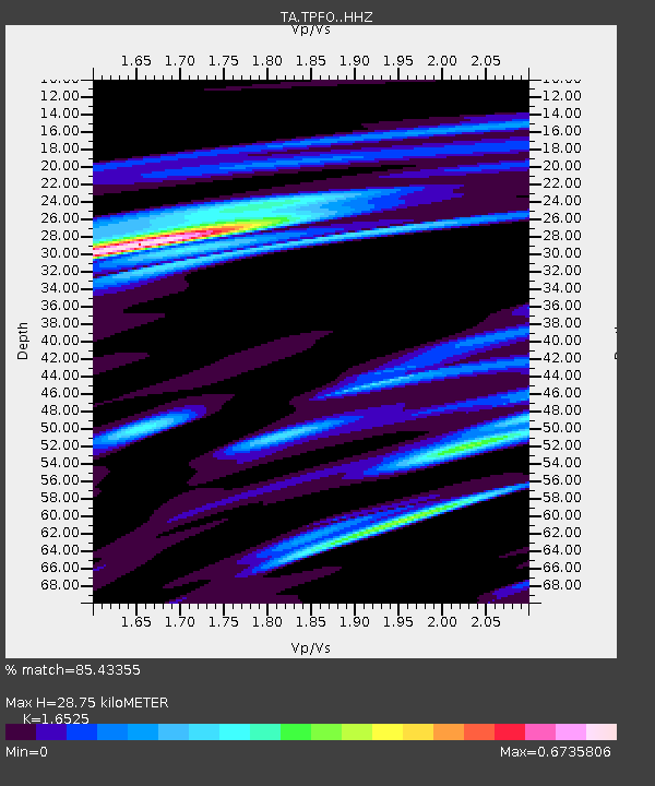
| Estimated Moho Depth: |
28.75 km |
| Estimated Crust Vp/Vs: |
1.65 |
| Assumed Crust Vp: |
6.264 km/s |
| Estimated Crust Vs: |
3.79 km/s |
| Estimated Crust Poisson's Ratio: |
0.21 |
|
| Radial Match: |
85.43355 % |
| Radial Bump: |
324 |
| Transverse Match: |
75.755264 % |
| Transverse Bump: |
323 |
| SOD ConfigId: |
11737051 |
| Insert Time: |
2019-04-25 02:07:49.297 +0000 |
| GWidth: |
2.5 |
| Max Bumps: |
400 |
| Tol: |
0.001 |
|
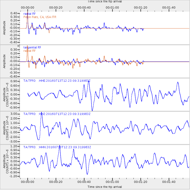
Signal To Noise
| Channel | StoN | STA | LTA |
| TA:TPFO: :HHZ:20160713T12:23:09.319983Z | 2.3500433 | 4.4185478E-7 | 1.8801985E-7 |
| TA:TPFO: :HHN:20160713T12:23:09.319983Z | 0.75987685 | 1.5243323E-7 | 2.0060254E-7 |
| TA:TPFO: :HHE:20160713T12:23:09.319983Z | 1.0506701 | 1.5714635E-7 | 1.4956773E-7 |
| Arrivals |
| Ps | 3.1 SECOND |
| PpPs | 12 SECOND |
| PsPs/PpSs | 15 SECOND |


