You are here: Home > Network List > UW - Pacific Northwest Regional Seismic Network Stations List
> Station YACT Amboy, WA, USA > Earthquake Result Viewer
YACT Amboy, WA, USA - Earthquake Result Viewer
| Earthquake location: |
Kermadec Islands Region |
| Earthquake latitude/longitude: |
-28.0/-176.4 |
| Earthquake time(UTC): |
2016/07/13 (195) 12:11:13 GMT |
| Earthquake Depth: |
12 km |
| Earthquake Magnitude: |
6.3 MWB |
| Earthquake Catalog/Contributor: |
NEIC PDE/NEIC COMCAT |
|
| Network: |
UW Pacific Northwest Regional Seismic Network |
| Station: |
YACT Amboy, WA, USA |
| Lat/Lon: |
45.93 N/122.42 W |
| Elevation: |
211 m |
|
| Distance: |
88.4 deg |
| Az: |
34.375 deg |
| Baz: |
225.655 deg |
| Ray Param: |
0.04261797 |
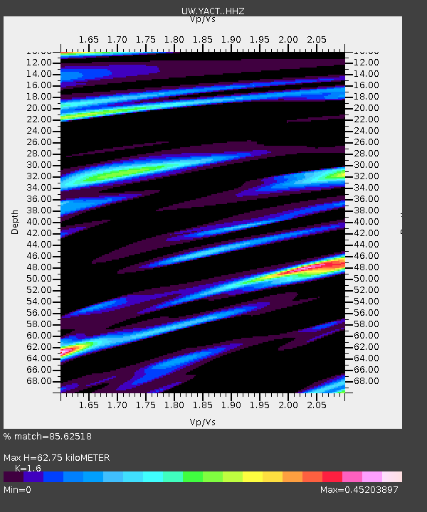
| Estimated Moho Depth: |
62.75 km |
| Estimated Crust Vp/Vs: |
1.60 |
| Assumed Crust Vp: |
6.566 km/s |
| Estimated Crust Vs: |
4.104 km/s |
| Estimated Crust Poisson's Ratio: |
0.18 |
|
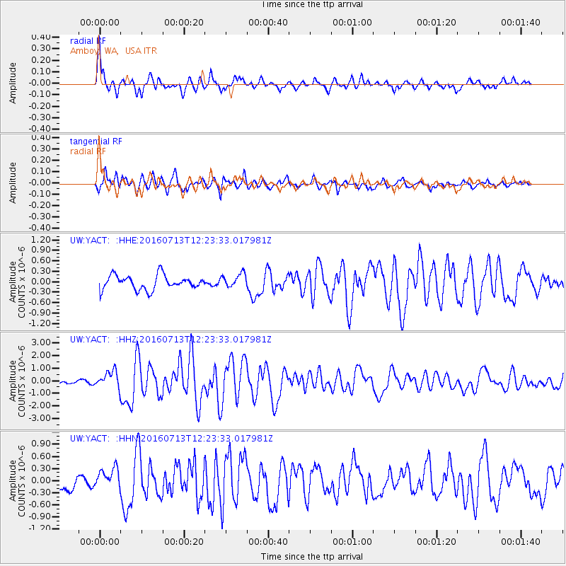
| Radial Match: |
85.62518 % |
| Radial Bump: |
400 |
| Transverse Match: |
83.49853 % |
| Transverse Bump: |
400 |
| SOD ConfigId: |
11737051 |
| Insert Time: |
2019-04-25 02:08:40.177 +0000 |
| GWidth: |
2.5 |
| Max Bumps: |
400 |
| Tol: |
0.001 |
|
Signal To Noise
| Channel | StoN | STA | LTA |
| UW:YACT: :HHZ:20160713T12:23:33.017981Z | 6.2684293 | 6.8961765E-7 | 1.10014426E-7 |
| UW:YACT: :HHN:20160713T12:23:33.017981Z | 1.2608112 | 2.5299957E-7 | 2.0066412E-7 |
| UW:YACT: :HHE:20160713T12:23:33.017981Z | 0.9747224 | 1.9350185E-7 | 1.9851996E-7 |
| Arrivals |
| Ps | 5.9 SECOND |
| PpPs | 24 SECOND |
| PsPs/PpSs | 30 SECOND |


