You are here: Home > Network List > XD14 - Illuminating the architecture of the greater Mount St. Helens magmatic systems f Stations List
> Station ME04 "Mount St Helens, WA" > Earthquake Result Viewer
ME04 "Mount St Helens, WA" - Earthquake Result Viewer
| Earthquake location: |
Kermadec Islands Region |
| Earthquake latitude/longitude: |
-28.0/-176.4 |
| Earthquake time(UTC): |
2016/07/13 (195) 12:11:13 GMT |
| Earthquake Depth: |
12 km |
| Earthquake Magnitude: |
6.3 MWB |
| Earthquake Catalog/Contributor: |
NEIC PDE/NEIC COMCAT |
|
| Network: |
XD Illuminating the architecture of the greater Mount St. Helens magmatic systems f |
| Station: |
ME04 "Mount St Helens, WA" |
| Lat/Lon: |
46.45 N/122.35 W |
| Elevation: |
730 m |
|
| Distance: |
88.8 deg |
| Az: |
34.037 deg |
| Baz: |
225.695 deg |
| Ray Param: |
0.04232296 |
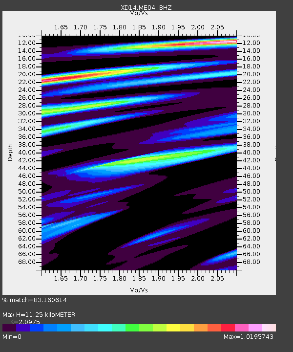
| Estimated Moho Depth: |
11.25 km |
| Estimated Crust Vp/Vs: |
2.10 |
| Assumed Crust Vp: |
6.566 km/s |
| Estimated Crust Vs: |
3.13 km/s |
| Estimated Crust Poisson's Ratio: |
0.35 |
|
| Radial Match: |
83.160614 % |
| Radial Bump: |
400 |
| Transverse Match: |
76.32045 % |
| Transverse Bump: |
400 |
| SOD ConfigId: |
11737051 |
| Insert Time: |
2019-04-25 02:08:59.308 +0000 |
| GWidth: |
2.5 |
| Max Bumps: |
400 |
| Tol: |
0.001 |
|

Signal To Noise
| Channel | StoN | STA | LTA |
| XD:ME04: :BHZ:20160713T12:23:34.900Z | 6.8186803 | 9.2110645E-7 | 1.3508574E-7 |
| XD:ME04: :BHN:20160713T12:23:34.900Z | 0.61387783 | 1.2115323E-7 | 1.9735725E-7 |
| XD:ME04: :BHE:20160713T12:23:34.900Z | 1.1959474 | 2.7227475E-7 | 2.276645E-7 |
| Arrivals |
| Ps | 1.9 SECOND |
| PpPs | 5.2 SECOND |
| PsPs/PpSs | 7.1 SECOND |


