You are here: Home > Network List > GS - US Geological Survey Networks Stations List
> Station KAN11 Stewart Ranch, Harper County, KS, USA > Earthquake Result Viewer
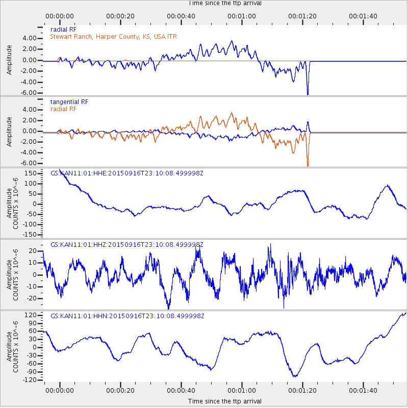
KAN11 Stewart Ranch, Harper County, KS, USA - Earthquake Result Viewer
*The percent match for this event was below the threshold and hence no stack was calculated.
| Earthquake location: |
Near Coast Of Central Chile |
| Earthquake latitude/longitude: |
-31.5/-71.9 |
| Earthquake time(UTC): |
2015/09/16 (259) 22:59:17 GMT |
| Earthquake Depth: |
48 km |
| Earthquake Magnitude: |
6.3 MB |
| Earthquake Catalog/Contributor: |
NEIC PDE/NEIC COMCAT |
|
| Network: |
GS US Geological Survey Networks |
| Station: |
KAN11 Stewart Ranch, Harper County, KS, USA |
| Lat/Lon: |
37.21 N/97.91 W |
| Elevation: |
410 m |
|
| Distance: |
72.6 deg |
| Az: |
338.482 deg |
| Baz: |
156.905 deg |
| Ray Param: |
$rayparam |
*The percent match for this event was below the threshold and hence was not used in the summary stack. |
|
| Radial Match: |
50.06299 % |
| Radial Bump: |
400 |
| Transverse Match: |
54.040577 % |
| Transverse Bump: |
400 |
| SOD ConfigId: |
1156111 |
| Insert Time: |
2015-09-30 23:31:52.353 +0000 |
| GWidth: |
2.5 |
| Max Bumps: |
400 |
| Tol: |
0.001 |
|
Signal To Noise
| Channel | StoN | STA | LTA |
| GS:KAN11:01:HHZ:20150916T23:10:08.499998Z | 1.0982198 | 1.011399E-5 | 9.209442E-6 |
| GS:KAN11:01:HHN:20150916T23:10:08.499998Z | 0.51414555 | 3.783774E-5 | 7.3593445E-5 |
| GS:KAN11:01:HHE:20150916T23:10:08.499998Z | 0.6845434 | 4.2394287E-5 | 6.1930754E-5 |
| Arrivals |
| Ps | |
| PpPs | |
| PsPs/PpSs | |


