You are here: Home > Network List > IU - Global Seismograph Network (GSN - IRIS/USGS) Stations List
> Station POHA Pohakuloa, Hawaii, USA > Earthquake Result Viewer
POHA Pohakuloa, Hawaii, USA - Earthquake Result Viewer

| Earthquake location: |
Near Coast Of Central Chile |
| Earthquake latitude/longitude: |
-31.5/-71.9 |
| Earthquake time(UTC): |
2015/09/16 (259) 22:59:17 GMT |
| Earthquake Depth: |
48 km |
| Earthquake Magnitude: |
6.3 MB |
| Earthquake Catalog/Contributor: |
NEIC PDE/NEIC COMCAT |
|
| Network: |
IU Global Seismograph Network (GSN - IRIS/USGS) |
| Station: |
POHA Pohakuloa, Hawaii, USA |
| Lat/Lon: |
19.76 N/155.53 W |
| Elevation: |
1990 m |
|
| Distance: |
94.9 deg |
| Az: |
290.039 deg |
| Baz: |
121.608 deg |
| Ray Param: |
0.04089677 |
| Estimated Moho Depth: |
12.25 km |
| Estimated Crust Vp/Vs: |
2.10 |
| Assumed Crust Vp: |
5.195 km/s |
| Estimated Crust Vs: |
2.477 km/s |
| Estimated Crust Poisson's Ratio: |
0.35 |
|
| Radial Match: |
85.867714 % |
| Radial Bump: |
380 |
| Transverse Match: |
74.45874 % |
| Transverse Bump: |
400 |
| SOD ConfigId: |
1156111 |
| Insert Time: |
2015-09-30 23:32:51.616 +0000 |
| GWidth: |
2.5 |
| Max Bumps: |
400 |
| Tol: |
0.001 |
|
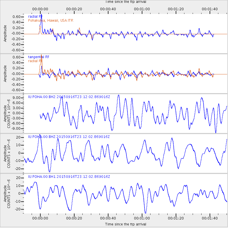
Signal To Noise
| Channel | StoN | STA | LTA |
| IU:POHA:00:BHZ:20150916T23:12:02.869016Z | 1.8262515 | 1.3712587E-5 | 7.5085973E-6 |
| IU:POHA:00:BH1:20150916T23:12:02.869016Z | 1.7404287 | 1.0060937E-5 | 5.7807238E-6 |
| IU:POHA:00:BH2:20150916T23:12:02.869016Z | 0.85723984 | 3.5643725E-6 | 4.157964E-6 |
| Arrivals |
| Ps | 2.6 SECOND |
| PpPs | 7.2 SECOND |
| PsPs/PpSs | 9.8 SECOND |


