You are here: Home > Network List > YH16 - Play Fairway Analysis - Passive monitoring of St. Helens Shear zone for tomograp Stations List
> Station MF00 Toutle, WA, USA > Earthquake Result Viewer
MF00 Toutle, WA, USA - Earthquake Result Viewer
| Earthquake location: |
Kermadec Islands Region |
| Earthquake latitude/longitude: |
-28.0/-176.4 |
| Earthquake time(UTC): |
2016/07/13 (195) 12:11:13 GMT |
| Earthquake Depth: |
12 km |
| Earthquake Magnitude: |
6.3 MWB |
| Earthquake Catalog/Contributor: |
NEIC PDE/NEIC COMCAT |
|
| Network: |
YH Play Fairway Analysis - Passive monitoring of St. Helens Shear zone for tomograp |
| Station: |
MF00 Toutle, WA, USA |
| Lat/Lon: |
46.35 N/122.24 W |
| Elevation: |
1221 m |
|
| Distance: |
88.8 deg |
| Az: |
34.164 deg |
| Baz: |
225.777 deg |
| Ray Param: |
0.04233557 |
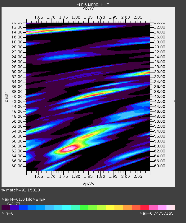
| Estimated Moho Depth: |
61.0 km |
| Estimated Crust Vp/Vs: |
1.77 |
| Assumed Crust Vp: |
6.566 km/s |
| Estimated Crust Vs: |
3.71 km/s |
| Estimated Crust Poisson's Ratio: |
0.27 |
|
| Radial Match: |
91.15318 % |
| Radial Bump: |
400 |
| Transverse Match: |
83.84873 % |
| Transverse Bump: |
400 |
| SOD ConfigId: |
11737051 |
| Insert Time: |
2019-04-25 02:10:02.323 +0000 |
| GWidth: |
2.5 |
| Max Bumps: |
400 |
| Tol: |
0.001 |
|

Signal To Noise
| Channel | StoN | STA | LTA |
| YH:MF00: :HHZ:20160713T12:23:34.805029Z | 4.6122756 | 7.287822E-7 | 1.5800926E-7 |
| YH:MF00: :HHN:20160713T12:23:34.805029Z | 1.4729041 | 2.8779544E-7 | 1.9539318E-7 |
| YH:MF00: :HHE:20160713T12:23:34.805029Z | 1.2805688 | 1.8196732E-7 | 1.4209883E-7 |
| Arrivals |
| Ps | 7.3 SECOND |
| PpPs | 25 SECOND |
| PsPs/PpSs | 32 SECOND |


