You are here: Home > Network List > YT07 - POLENET Stations List
> Station HOWD HOWD > Earthquake Result Viewer
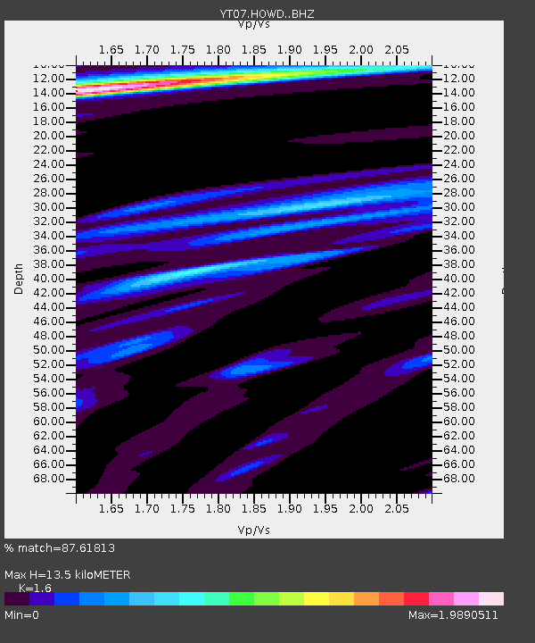
HOWD HOWD - Earthquake Result Viewer
| Earthquake location: |
Kermadec Islands Region |
| Earthquake latitude/longitude: |
-28.0/-176.4 |
| Earthquake time(UTC): |
2016/07/13 (195) 12:11:13 GMT |
| Earthquake Depth: |
12 km |
| Earthquake Magnitude: |
6.3 MWB |
| Earthquake Catalog/Contributor: |
NEIC PDE/NEIC COMCAT |
|
| Network: |
YT POLENET |
| Station: |
HOWD HOWD |
| Lat/Lon: |
77.53 S/86.77 W |
| Elevation: |
1495 m |
|
| Distance: |
62.8 deg |
| Az: |
165.852 deg |
| Baz: |
263.812 deg |
| Ray Param: |
0.06000705 |
| Estimated Moho Depth: |
13.5 km |
| Estimated Crust Vp/Vs: |
1.60 |
| Assumed Crust Vp: |
6.047 km/s |
| Estimated Crust Vs: |
3.779 km/s |
| Estimated Crust Poisson's Ratio: |
0.18 |
|
| Radial Match: |
87.61813 % |
| Radial Bump: |
400 |
| Transverse Match: |
60.65407 % |
| Transverse Bump: |
400 |
| SOD ConfigId: |
11737051 |
| Insert Time: |
2019-04-25 02:10:16.636 +0000 |
| GWidth: |
2.5 |
| Max Bumps: |
400 |
| Tol: |
0.001 |
|

Signal To Noise
| Channel | StoN | STA | LTA |
| YT:HOWD: :BHZ:20160713T12:21:06.999976Z | 3.4639099 | 5.9214034E-7 | 1.7094567E-7 |
| YT:HOWD: :BHN:20160713T12:21:06.999976Z | 1.0317725 | 1.9030583E-7 | 1.8444553E-7 |
| YT:HOWD: :BHE:20160713T12:21:06.999976Z | 1.5972862 | 3.6618056E-7 | 2.2925168E-7 |
| Arrivals |
| Ps | 1.4 SECOND |
| PpPs | 5.6 SECOND |
| PsPs/PpSs | 7.0 SECOND |


