You are here: Home > Network List > CI - Caltech Regional Seismic Network Stations List
> Station RRX Rimrock Road, Barstow, CA, USA > Earthquake Result Viewer
RRX Rimrock Road, Barstow, CA, USA - Earthquake Result Viewer
| Earthquake location: |
Near Coast Of Peru |
| Earthquake latitude/longitude: |
-13.6/-76.6 |
| Earthquake time(UTC): |
2007/08/19 (231) 01:22:40 GMT |
| Earthquake Depth: |
26 km |
| Earthquake Magnitude: |
5.9 MB, 5.4 MS, 5.8 MW, 5.5 ML |
| Earthquake Catalog/Contributor: |
WHDF/NEIC |
|
| Network: |
CI Caltech Regional Seismic Network |
| Station: |
RRX Rimrock Road, Barstow, CA, USA |
| Lat/Lon: |
34.88 N/117.00 W |
| Elevation: |
439 m |
|
| Distance: |
61.6 deg |
| Az: |
322.731 deg |
| Baz: |
134.271 deg |
| Ray Param: |
0.060734343 |
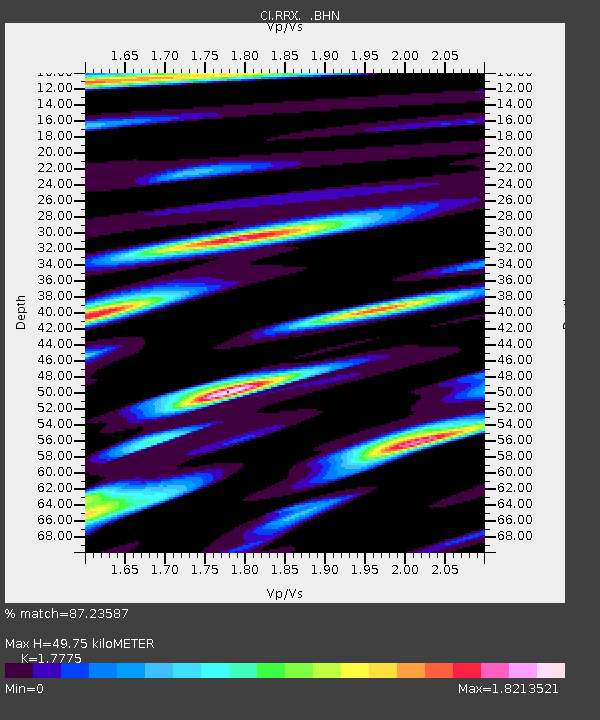
| Estimated Moho Depth: |
49.75 km |
| Estimated Crust Vp/Vs: |
1.78 |
| Assumed Crust Vp: |
6.276 km/s |
| Estimated Crust Vs: |
3.531 km/s |
| Estimated Crust Poisson's Ratio: |
0.27 |
|
| Radial Match: |
87.23587 % |
| Radial Bump: |
400 |
| Transverse Match: |
78.18689 % |
| Transverse Bump: |
400 |
| SOD ConfigId: |
2564 |
| Insert Time: |
2010-02-26 00:34:56.210 +0000 |
| GWidth: |
2.5 |
| Max Bumps: |
400 |
| Tol: |
0.001 |
|
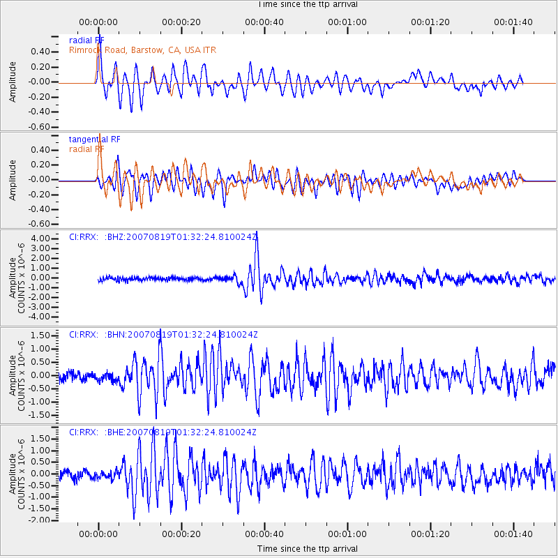
Signal To Noise
| Channel | StoN | STA | LTA |
| CI:RRX: :BHN:20070819T01:32:24.810024Z | 0.76862085 | 1.4049581E-7 | 1.8278949E-7 |
| CI:RRX: :BHE:20070819T01:32:24.810024Z | 0.5627071 | 1.4901244E-7 | 2.6481348E-7 |
| CI:RRX: :BHZ:20070819T01:32:24.810024Z | 2.330296 | 3.6124234E-7 | 1.5501993E-7 |
| Arrivals |
| Ps | 6.4 SECOND |
| PpPs | 21 SECOND |
| PsPs/PpSs | 28 SECOND |


