You are here: Home > Network List > TA - USArray Transportable Network (new EarthScope stations) Stations List
> Station R11A Troy Canyon, Currant, NV, USA > Earthquake Result Viewer
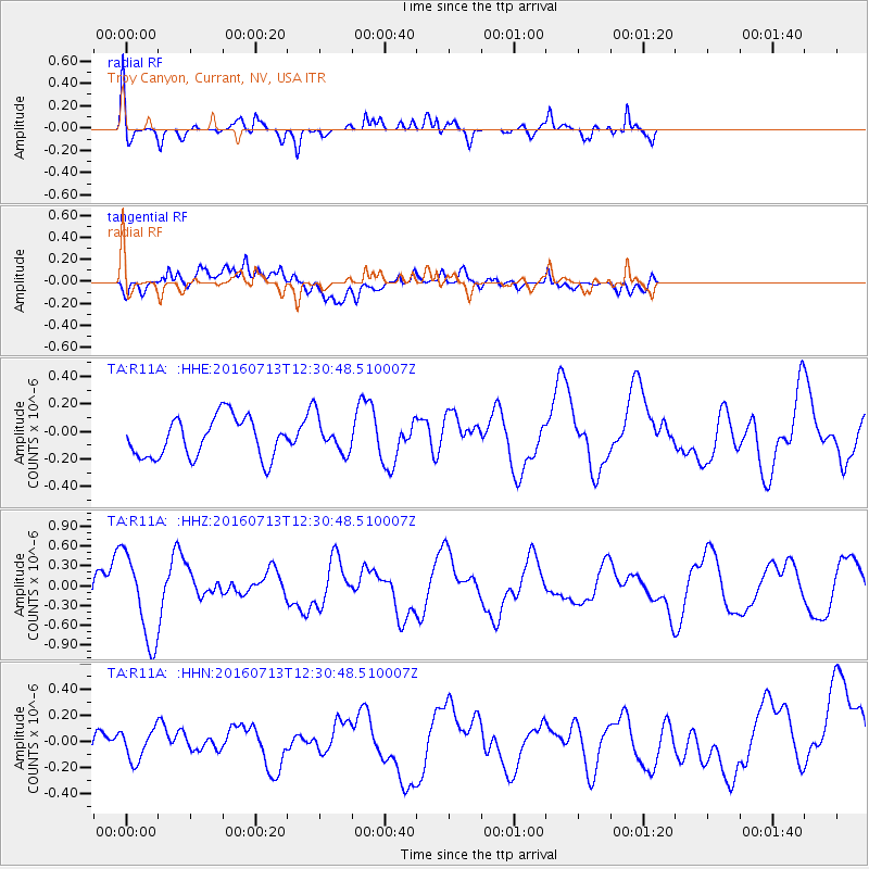
R11A Troy Canyon, Currant, NV, USA - Earthquake Result Viewer
*The percent match for this event was below the threshold and hence no stack was calculated.
| Earthquake location: |
Kermadec Islands Region |
| Earthquake latitude/longitude: |
-28.1/-176.6 |
| Earthquake time(UTC): |
2016/07/13 (195) 12:18:33 GMT |
| Earthquake Depth: |
10 km |
| Earthquake Magnitude: |
5.7 MB |
| Earthquake Catalog/Contributor: |
NEIC PDE/NEIC COMCAT |
|
| Network: |
TA USArray Transportable Network (new EarthScope stations) |
| Station: |
R11A Troy Canyon, Currant, NV, USA |
| Lat/Lon: |
38.35 N/115.59 W |
| Elevation: |
1756 m |
|
| Distance: |
87.3 deg |
| Az: |
43.489 deg |
| Baz: |
230.619 deg |
| Ray Param: |
$rayparam |
*The percent match for this event was below the threshold and hence was not used in the summary stack. |
|
| Radial Match: |
65.577896 % |
| Radial Bump: |
400 |
| Transverse Match: |
55.06414 % |
| Transverse Bump: |
400 |
| SOD ConfigId: |
11737051 |
| Insert Time: |
2019-04-25 02:15:54.658 +0000 |
| GWidth: |
2.5 |
| Max Bumps: |
400 |
| Tol: |
0.001 |
|
Signal To Noise
| Channel | StoN | STA | LTA |
| TA:R11A: :HHZ:20160713T12:30:48.510007Z | 2.5188808 | 6.5858046E-7 | 2.6145756E-7 |
| TA:R11A: :HHN:20160713T12:30:48.510007Z | 0.98679614 | 1.2352685E-7 | 1.2517971E-7 |
| TA:R11A: :HHE:20160713T12:30:48.510007Z | 0.64999014 | 9.389673E-8 | 1.444587E-7 |
| Arrivals |
| Ps | |
| PpPs | |
| PsPs/PpSs | |


