You are here: Home > Network List > GS - US Geological Survey Networks Stations List
> Station DEC05 Decatur Surface Seismic Site, Decatur, IL, USA > Earthquake Result Viewer
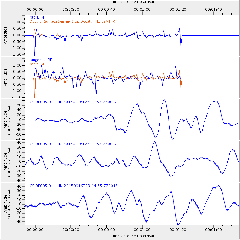
DEC05 Decatur Surface Seismic Site, Decatur, IL, USA - Earthquake Result Viewer
*The percent match for this event was below the threshold and hence no stack was calculated.
| Earthquake location: |
Near Coast Of Central Chile |
| Earthquake latitude/longitude: |
-31.8/-71.6 |
| Earthquake time(UTC): |
2015/09/16 (259) 23:03:56 GMT |
| Earthquake Depth: |
10 km |
| Earthquake Magnitude: |
6.1 MB |
| Earthquake Catalog/Contributor: |
NEIC PDE/NEIC COMCAT |
|
| Network: |
GS US Geological Survey Networks |
| Station: |
DEC05 Decatur Surface Seismic Site, Decatur, IL, USA |
| Lat/Lon: |
39.87 N/88.87 W |
| Elevation: |
216 m |
|
| Distance: |
73.1 deg |
| Az: |
346.163 deg |
| Baz: |
164.664 deg |
| Ray Param: |
$rayparam |
*The percent match for this event was below the threshold and hence was not used in the summary stack. |
|
| Radial Match: |
43.22986 % |
| Radial Bump: |
400 |
| Transverse Match: |
61.597206 % |
| Transverse Bump: |
327 |
| SOD ConfigId: |
1156111 |
| Insert Time: |
2015-09-30 23:39:58.080 +0000 |
| GWidth: |
2.5 |
| Max Bumps: |
400 |
| Tol: |
0.001 |
|
Signal To Noise
| Channel | StoN | STA | LTA |
| GS:DEC05:01:HHZ:20150916T23:14:55.77001Z | 0.91060346 | 6.258584E-6 | 6.873007E-6 |
| GS:DEC05:01:HHN:20150916T23:14:55.77001Z | 0.8790013 | 4.033124E-6 | 4.5883025E-6 |
| GS:DEC05:01:HHE:20150916T23:14:55.77001Z | 1.5445348 | 6.5212344E-6 | 4.222135E-6 |
| Arrivals |
| Ps | |
| PpPs | |
| PsPs/PpSs | |


