You are here: Home > Network List > GS - US Geological Survey Networks Stations List
> Station DEC08 Decatur Surface Seismic Site, Decatur, IL, USA > Earthquake Result Viewer
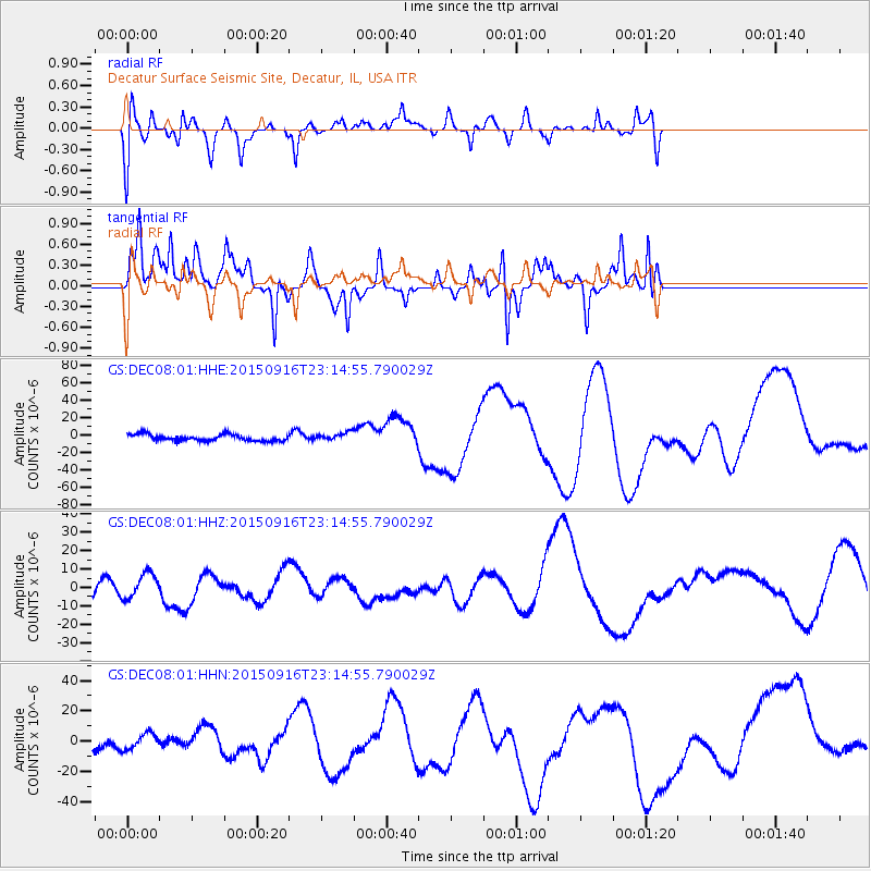
DEC08 Decatur Surface Seismic Site, Decatur, IL, USA - Earthquake Result Viewer
*The percent match for this event was below the threshold and hence no stack was calculated.
| Earthquake location: |
Near Coast Of Central Chile |
| Earthquake latitude/longitude: |
-31.8/-71.6 |
| Earthquake time(UTC): |
2015/09/16 (259) 23:03:56 GMT |
| Earthquake Depth: |
10 km |
| Earthquake Magnitude: |
6.1 MB |
| Earthquake Catalog/Contributor: |
NEIC PDE/NEIC COMCAT |
|
| Network: |
GS US Geological Survey Networks |
| Station: |
DEC08 Decatur Surface Seismic Site, Decatur, IL, USA |
| Lat/Lon: |
39.86 N/88.92 W |
| Elevation: |
210 m |
|
| Distance: |
73.1 deg |
| Az: |
346.115 deg |
| Baz: |
164.613 deg |
| Ray Param: |
$rayparam |
*The percent match for this event was below the threshold and hence was not used in the summary stack. |
|
| Radial Match: |
41.538292 % |
| Radial Bump: |
400 |
| Transverse Match: |
65.57534 % |
| Transverse Bump: |
316 |
| SOD ConfigId: |
1156111 |
| Insert Time: |
2015-09-30 23:40:09.520 +0000 |
| GWidth: |
2.5 |
| Max Bumps: |
400 |
| Tol: |
0.001 |
|
Signal To Noise
| Channel | StoN | STA | LTA |
| GS:DEC08:01:HHZ:20150916T23:14:55.790029Z | 1.060878 | 6.6076104E-6 | 6.2284357E-6 |
| GS:DEC08:01:HHN:20150916T23:14:55.790029Z | 1.3292192 | 5.3604404E-6 | 4.0327736E-6 |
| GS:DEC08:01:HHE:20150916T23:14:55.790029Z | 1.2617968 | 4.629075E-6 | 3.6686374E-6 |
| Arrivals |
| Ps | |
| PpPs | |
| PsPs/PpSs | |


