You are here: Home > Network List > US - United States National Seismic Network Stations List
> Station BMO Blue Mountains Array (Baker), Oregon, USA > Earthquake Result Viewer
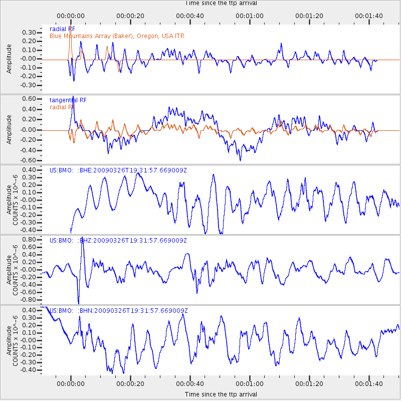
BMO Blue Mountains Array (Baker), Oregon, USA - Earthquake Result Viewer
*The percent match for this event was below the threshold and hence no stack was calculated.
| Earthquake location: |
Northwest Of Ryukyu Islands |
| Earthquake latitude/longitude: |
27.4/126.7 |
| Earthquake time(UTC): |
2009/03/26 (085) 19:19:59 GMT |
| Earthquake Depth: |
160 km |
| Earthquake Magnitude: |
5.6 MB, 5.9 MW, 5.9 MW |
| Earthquake Catalog/Contributor: |
WHDF/NEIC |
|
| Network: |
US United States National Seismic Network |
| Station: |
BMO Blue Mountains Array (Baker), Oregon, USA |
| Lat/Lon: |
44.85 N/117.31 W |
| Elevation: |
1189 m |
|
| Distance: |
87.4 deg |
| Az: |
39.794 deg |
| Baz: |
306.885 deg |
| Ray Param: |
$rayparam |
*The percent match for this event was below the threshold and hence was not used in the summary stack. |
|
| Radial Match: |
65.8461 % |
| Radial Bump: |
400 |
| Transverse Match: |
44.00969 % |
| Transverse Bump: |
400 |
| SOD ConfigId: |
2658 |
| Insert Time: |
2010-03-05 05:22:27.509 +0000 |
| GWidth: |
2.5 |
| Max Bumps: |
400 |
| Tol: |
0.001 |
|
Signal To Noise
| Channel | StoN | STA | LTA |
| US:BMO: :BHZ:20090326T19:31:57.669009Z | 3.7426307 | 4.0242418E-7 | 1.07524414E-7 |
| US:BMO: :BHN:20090326T19:31:57.669009Z | 0.37278992 | 1.0553638E-7 | 2.8309879E-7 |
| US:BMO: :BHE:20090326T19:31:57.669009Z | 0.80281186 | 1.536058E-7 | 1.9133475E-7 |
| Arrivals |
| Ps | |
| PpPs | |
| PsPs/PpSs | |


