You are here: Home > Network List > GS - US Geological Survey Networks Stations List
> Station KAN13 Rinehart Farm > Earthquake Result Viewer
KAN13 Rinehart Farm - Earthquake Result Viewer
*The percent match for this event was below the threshold and hence no stack was calculated.
| Earthquake location: |
Northern Mid-Atlantic Ridge |
| Earthquake latitude/longitude: |
35.2/-35.2 |
| Earthquake time(UTC): |
2016/07/15 (197) 18:02:49 GMT |
| Earthquake Depth: |
16 km |
| Earthquake Magnitude: |
5.5 mwb |
| Earthquake Catalog/Contributor: |
NEIC PDE/ |
|
| Network: |
GS US Geological Survey Networks |
| Station: |
KAN13 Rinehart Farm |
| Lat/Lon: |
37.01 N/97.48 W |
| Elevation: |
340 m |
|
| Distance: |
49.5 deg |
| Az: |
291.354 deg |
| Baz: |
72.328 deg |
| Ray Param: |
$rayparam |
*The percent match for this event was below the threshold and hence was not used in the summary stack. |
|
| Radial Match: |
49.81747 % |
| Radial Bump: |
400 |
| Transverse Match: |
62.164646 % |
| Transverse Bump: |
400 |
| SOD ConfigId: |
11737051 |
| Insert Time: |
2019-04-25 02:34:50.266 +0000 |
| GWidth: |
2.5 |
| Max Bumps: |
400 |
| Tol: |
0.001 |
|
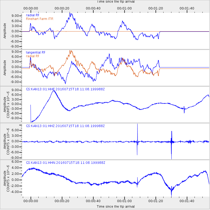
Signal To Noise
| Channel | StoN | STA | LTA |
| GS:KAN13:01:HHZ:20160715T18:11:08.199988Z | 1.475526 | 1.5576805E-7 | 1.0556782E-7 |
| GS:KAN13:01:HHN:20160715T18:11:08.199988Z | 2.8461316 | 9.014086E-6 | 3.167136E-6 |
| GS:KAN13:01:HHE:20160715T18:11:08.199988Z | 0.068268165 | 4.1129636E-7 | 6.0247166E-6 |
| Arrivals |
| Ps | |
| PpPs | |
| PsPs/PpSs | |


