You are here: Home > Network List > LD - Lamont-Doherty Cooperative Seismographic Network Stations List
> Station MVL Millersville University, PA > Earthquake Result Viewer
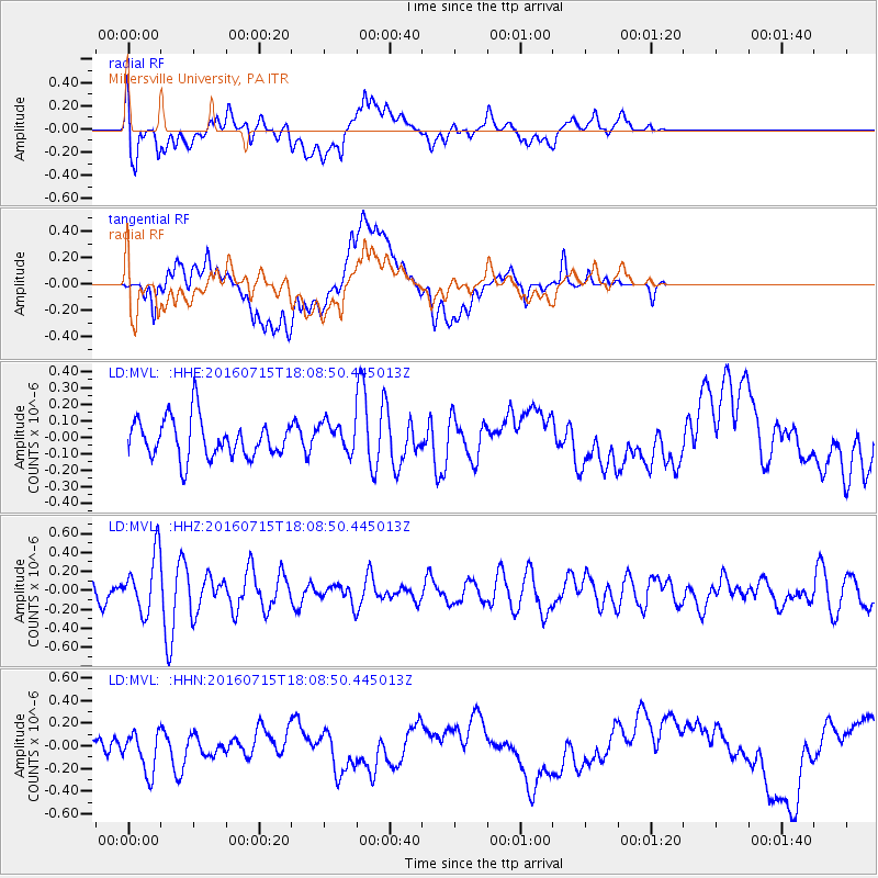
MVL Millersville University, PA - Earthquake Result Viewer
*The percent match for this event was below the threshold and hence no stack was calculated.
| Earthquake location: |
Northern Mid-Atlantic Ridge |
| Earthquake latitude/longitude: |
35.2/-35.2 |
| Earthquake time(UTC): |
2016/07/15 (197) 18:02:49 GMT |
| Earthquake Depth: |
16 km |
| Earthquake Magnitude: |
5.5 mwb |
| Earthquake Catalog/Contributor: |
NEIC PDE/ |
|
| Network: |
LD Lamont-Doherty Cooperative Seismographic Network |
| Station: |
MVL Millersville University, PA |
| Lat/Lon: |
40.00 N/76.35 W |
| Elevation: |
91 m |
|
| Distance: |
32.7 deg |
| Az: |
290.824 deg |
| Baz: |
85.12 deg |
| Ray Param: |
$rayparam |
*The percent match for this event was below the threshold and hence was not used in the summary stack. |
|
| Radial Match: |
36.80838 % |
| Radial Bump: |
400 |
| Transverse Match: |
32.033752 % |
| Transverse Bump: |
400 |
| SOD ConfigId: |
11737051 |
| Insert Time: |
2019-04-25 02:35:33.373 +0000 |
| GWidth: |
2.5 |
| Max Bumps: |
400 |
| Tol: |
0.001 |
|
Signal To Noise
| Channel | StoN | STA | LTA |
| LD:MVL: :HHZ:20160715T18:08:50.445013Z | 3.563304 | 3.0221955E-7 | 8.4814424E-8 |
| LD:MVL: :HHN:20160715T18:08:50.445013Z | 2.1466146 | 1.8015086E-7 | 8.392325E-8 |
| LD:MVL: :HHE:20160715T18:08:50.445013Z | 0.75913554 | 8.937256E-8 | 1.1772939E-7 |
| Arrivals |
| Ps | |
| PpPs | |
| PsPs/PpSs | |


