You are here: Home > Network List > WY - Yellowstone Wyoming Seismic Network Stations List
> Station YHR Hawk's Rest, WY, USA > Earthquake Result Viewer
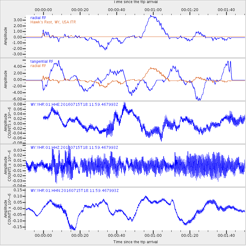
YHR Hawk's Rest, WY, USA - Earthquake Result Viewer
*The percent match for this event was below the threshold and hence no stack was calculated.
| Earthquake location: |
Northern Mid-Atlantic Ridge |
| Earthquake latitude/longitude: |
35.2/-35.2 |
| Earthquake time(UTC): |
2016/07/15 (197) 18:02:49 GMT |
| Earthquake Depth: |
16 km |
| Earthquake Magnitude: |
5.5 mwb |
| Earthquake Catalog/Contributor: |
NEIC PDE/ |
|
| Network: |
WY Yellowstone Wyoming Seismic Network |
| Station: |
YHR Hawk's Rest, WY, USA |
| Lat/Lon: |
44.11 N/110.08 W |
| Elevation: |
2976 m |
|
| Distance: |
56.5 deg |
| Az: |
303.482 deg |
| Baz: |
71.459 deg |
| Ray Param: |
$rayparam |
*The percent match for this event was below the threshold and hence was not used in the summary stack. |
|
| Radial Match: |
16.052216 % |
| Radial Bump: |
400 |
| Transverse Match: |
37.42639 % |
| Transverse Bump: |
400 |
| SOD ConfigId: |
11737051 |
| Insert Time: |
2019-04-25 02:39:37.543 +0000 |
| GWidth: |
2.5 |
| Max Bumps: |
400 |
| Tol: |
0.001 |
|
Signal To Noise
| Channel | StoN | STA | LTA |
| WY:YHR:01:HHZ:20160715T18:11:59.467993Z | 0.9041031 | 6.6400694E-9 | 7.3443713E-9 |
| WY:YHR:01:HHN:20160715T18:11:59.467993Z | 0.51221937 | 3.3614278E-8 | 6.562476E-8 |
| WY:YHR:01:HHE:20160715T18:11:59.467993Z | 1.9845947 | 4.5521652E-8 | 2.2937504E-8 |
| Arrivals |
| Ps | |
| PpPs | |
| PsPs/PpSs | |


