You are here: Home > Network List > N4 - Central and EAstern US Network Stations List
> Station U49A Red Boiling Springs, TN, USA > Earthquake Result Viewer
U49A Red Boiling Springs, TN, USA - Earthquake Result Viewer
| Earthquake location: |
Off Coast Of Central Chile |
| Earthquake latitude/longitude: |
-30.2/-72.0 |
| Earthquake time(UTC): |
2016/07/19 (201) 05:18:40 GMT |
| Earthquake Depth: |
14 km |
| Earthquake Magnitude: |
5.5 MB |
| Earthquake Catalog/Contributor: |
NEIC PDE/NEIC COMCAT |
|
| Network: |
N4 Central and EAstern US Network |
| Station: |
U49A Red Boiling Springs, TN, USA |
| Lat/Lon: |
36.51 N/85.78 W |
| Elevation: |
234 m |
|
| Distance: |
67.6 deg |
| Az: |
348.04 deg |
| Baz: |
167.131 deg |
| Ray Param: |
0.05684723 |
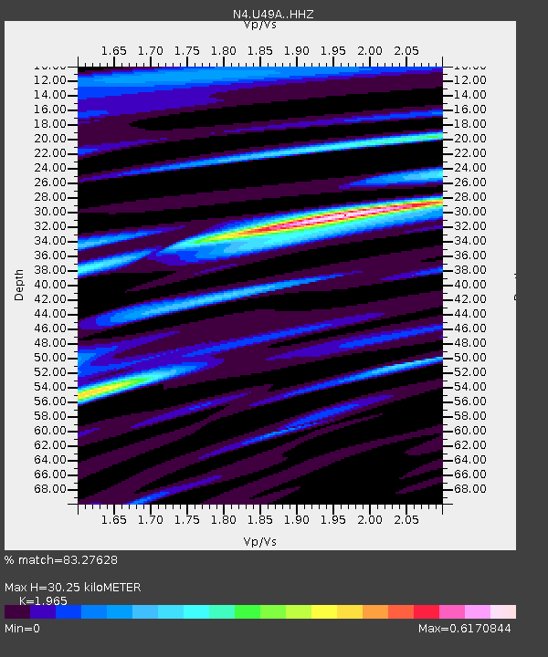
| Estimated Moho Depth: |
30.25 km |
| Estimated Crust Vp/Vs: |
1.97 |
| Assumed Crust Vp: |
6.476 km/s |
| Estimated Crust Vs: |
3.296 km/s |
| Estimated Crust Poisson's Ratio: |
0.33 |
|
| Radial Match: |
83.27628 % |
| Radial Bump: |
400 |
| Transverse Match: |
61.98383 % |
| Transverse Bump: |
400 |
| SOD ConfigId: |
11737051 |
| Insert Time: |
2019-04-25 02:46:31.173 +0000 |
| GWidth: |
2.5 |
| Max Bumps: |
400 |
| Tol: |
0.001 |
|

Signal To Noise
| Channel | StoN | STA | LTA |
| N4:U49A: :HHZ:20160719T05:29:06.529983Z | 10.120208 | 4.3733303E-7 | 4.3213838E-8 |
| N4:U49A: :HHN:20160719T05:29:06.529983Z | 3.7645833 | 1.6578505E-7 | 4.4038085E-8 |
| N4:U49A: :HHE:20160719T05:29:06.529983Z | 1.3421577 | 6.069495E-8 | 4.5221924E-8 |
| Arrivals |
| Ps | 4.7 SECOND |
| PpPs | 13 SECOND |
| PsPs/PpSs | 18 SECOND |


