You are here: Home > Network List > US - United States National Seismic Network Stations List
> Station NLWA Neilton Lookout, Washington, USA > Earthquake Result Viewer
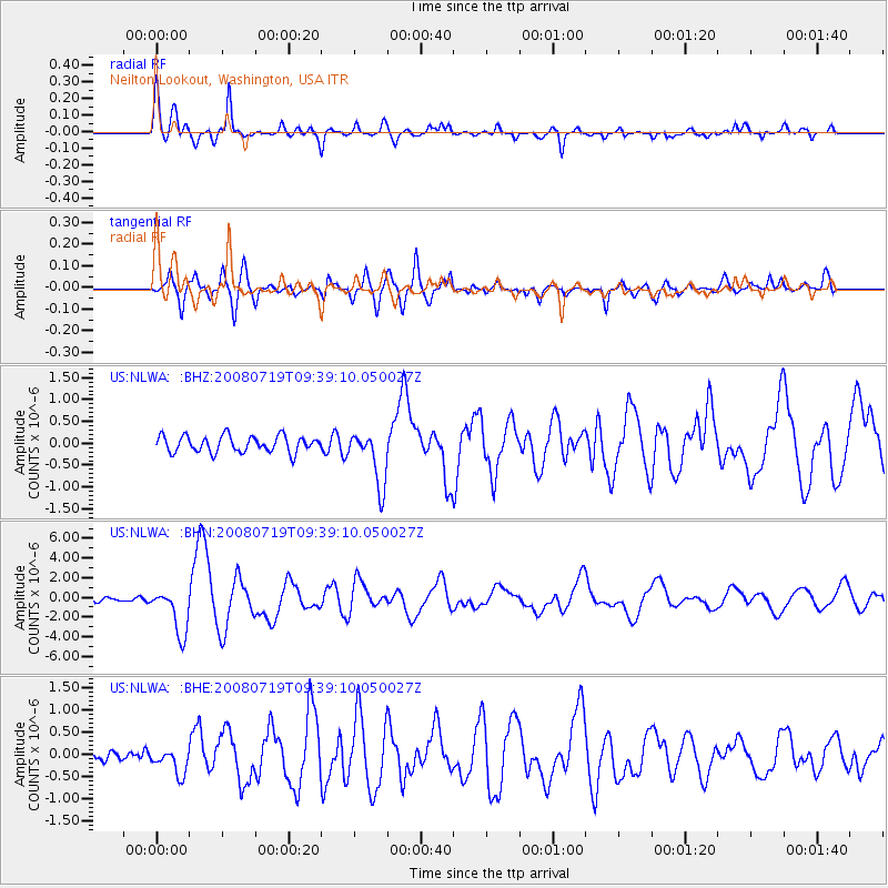
NLWA Neilton Lookout, Washington, USA - Earthquake Result Viewer

| Earthquake location: |
Santa Cruz Islands Region |
| Earthquake latitude/longitude: |
-11.0/164.5 |
| Earthquake time(UTC): |
2008/07/19 (201) 09:27:01 GMT |
| Earthquake Depth: |
11 km |
| Earthquake Magnitude: |
6.1 MB, 6.4 MS, 6.6 MW, 6.6 MW |
| Earthquake Catalog/Contributor: |
WHDF/NEIC |
|
| Network: |
US United States National Seismic Network |
| Station: |
NLWA Neilton Lookout, Washington, USA |
| Lat/Lon: |
47.39 N/123.87 W |
| Elevation: |
610 m |
|
| Distance: |
86.0 deg |
| Az: |
40.276 deg |
| Baz: |
249.078 deg |
| Ray Param: |
0.044392917 |
| Estimated Moho Depth: |
28.5 km |
| Estimated Crust Vp/Vs: |
1.60 |
| Assumed Crust Vp: |
6.566 km/s |
| Estimated Crust Vs: |
4.104 km/s |
| Estimated Crust Poisson's Ratio: |
0.18 |
|
| Radial Match: |
91.73641 % |
| Radial Bump: |
400 |
| Transverse Match: |
86.387344 % |
| Transverse Bump: |
400 |
| SOD ConfigId: |
2658 |
| Insert Time: |
2010-03-05 05:24:27.047 +0000 |
| GWidth: |
2.5 |
| Max Bumps: |
400 |
| Tol: |
0.001 |
|
Signal To Noise
| Channel | StoN | STA | LTA |
| US:NLWA: :BHN:20080719T09:39:10.050027Z | 13.655865 | 2.3711066E-6 | 1.7363284E-7 |
| US:NLWA: :BHE:20080719T09:39:10.050027Z | 2.7595854 | 2.9372097E-7 | 1.0643662E-7 |
| US:NLWA: :BHZ:20080719T09:39:10.050027Z | 3.3833315 | 6.30732E-7 | 1.8642336E-7 |
| Arrivals |
| Ps | 2.7 SECOND |
| PpPs | 11 SECOND |
| PsPs/PpSs | 14 SECOND |


