You are here: Home > Network List > US - United States National Seismic Network Stations List
> Station NLWA Neilton Lookout, Washington, USA > Earthquake Result Viewer
NLWA Neilton Lookout, Washington, USA - Earthquake Result Viewer
| Earthquake location: |
Kuril Islands |
| Earthquake latitude/longitude: |
48.3/154.2 |
| Earthquake time(UTC): |
2006/11/12 (316) 21:27:42 GMT |
| Earthquake Depth: |
36 km |
| Earthquake Magnitude: |
6.1 MB, 5.4 MS, 5.9 MW, 5.9 MW |
| Earthquake Catalog/Contributor: |
WHDF/NEIC |
|
| Network: |
US United States National Seismic Network |
| Station: |
NLWA Neilton Lookout, Washington, USA |
| Lat/Lon: |
47.39 N/123.87 W |
| Elevation: |
610 m |
|
| Distance: |
52.4 deg |
| Az: |
58.099 deg |
| Baz: |
303.426 deg |
| Ray Param: |
0.06671154 |
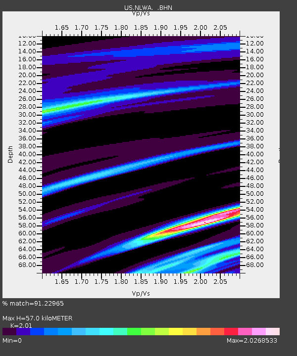
| Estimated Moho Depth: |
57.0 km |
| Estimated Crust Vp/Vs: |
2.01 |
| Assumed Crust Vp: |
6.566 km/s |
| Estimated Crust Vs: |
3.267 km/s |
| Estimated Crust Poisson's Ratio: |
0.34 |
|
| Radial Match: |
91.22965 % |
| Radial Bump: |
162 |
| Transverse Match: |
33.67457 % |
| Transverse Bump: |
384 |
| SOD ConfigId: |
2564 |
| Insert Time: |
2010-03-05 05:26:04.114 +0000 |
| GWidth: |
2.5 |
| Max Bumps: |
400 |
| Tol: |
0.001 |
|

Signal To Noise
| Channel | StoN | STA | LTA |
| US:NLWA: :BHN:20061112T21:36:20.59802Z | 1.6397218 | 1.3736958E-6 | 8.3776155E-7 |
| US:NLWA: :BHE:20061112T21:36:20.59802Z | 0.845881 | 9.352436E-6 | 1.1056444E-5 |
| US:NLWA: :BHZ:20061112T21:36:20.59802Z | 1.7402725 | 1.130797E-6 | 6.4978155E-7 |
| Arrivals |
| Ps | 9.2 SECOND |
| PpPs | 25 SECOND |
| PsPs/PpSs | 34 SECOND |


