You are here: Home > Network List > GS - US Geological Survey Networks Stations List
> Station KAN10 Keim Farm, Anthony, KS, USA > Earthquake Result Viewer
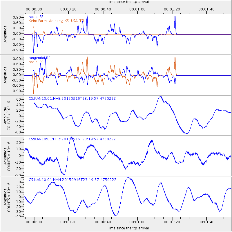
KAN10 Keim Farm, Anthony, KS, USA - Earthquake Result Viewer
*The percent match for this event was below the threshold and hence no stack was calculated.
| Earthquake location: |
Near Coast Of Central Chile |
| Earthquake latitude/longitude: |
-31.1/-71.3 |
| Earthquake time(UTC): |
2015/09/16 (259) 23:09:05 GMT |
| Earthquake Depth: |
26 km |
| Earthquake Magnitude: |
5.6 MB |
| Earthquake Catalog/Contributor: |
NEIC PDE/NEIC COMCAT |
|
| Network: |
GS US Geological Survey Networks |
| Station: |
KAN10 Keim Farm, Anthony, KS, USA |
| Lat/Lon: |
37.12 N/98.10 W |
| Elevation: |
417 m |
|
| Distance: |
72.4 deg |
| Az: |
337.816 deg |
| Baz: |
156.097 deg |
| Ray Param: |
$rayparam |
*The percent match for this event was below the threshold and hence was not used in the summary stack. |
|
| Radial Match: |
53.80308 % |
| Radial Bump: |
217 |
| Transverse Match: |
59.916103 % |
| Transverse Bump: |
281 |
| SOD ConfigId: |
1156111 |
| Insert Time: |
2015-09-30 23:49:32.919 +0000 |
| GWidth: |
2.5 |
| Max Bumps: |
400 |
| Tol: |
0.001 |
|
Signal To Noise
| Channel | StoN | STA | LTA |
| GS:KAN10:01:HHZ:20150916T23:19:57.475022Z | 1.3442101 | 9.202998E-6 | 6.8463983E-6 |
| GS:KAN10:01:HHN:20150916T23:19:57.475022Z | 1.6539143 | 1.323493E-5 | 8.0021855E-6 |
| GS:KAN10:01:HHE:20150916T23:19:57.475022Z | 1.018488 | 2.2637647E-5 | 2.2226719E-5 |
| Arrivals |
| Ps | |
| PpPs | |
| PsPs/PpSs | |


