You are here: Home > Network List > CN - Canadian National Seismograph Network Stations List
> Station INK INUVIK, NT > Earthquake Result Viewer
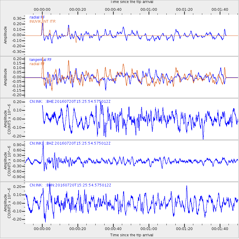
INK INUVIK, NT - Earthquake Result Viewer
*The percent match for this event was below the threshold and hence no stack was calculated.
| Earthquake location: |
Vanuatu Islands |
| Earthquake latitude/longitude: |
-18.9/169.0 |
| Earthquake time(UTC): |
2016/07/20 (202) 15:13:16 GMT |
| Earthquake Depth: |
164 km |
| Earthquake Magnitude: |
6.0 MO |
| Earthquake Catalog/Contributor: |
NEIC PDE/NEIC ALERT |
|
| Network: |
CN Canadian National Seismograph Network |
| Station: |
INK INUVIK, NT |
| Lat/Lon: |
68.31 N/133.53 W |
| Elevation: |
44 m |
|
| Distance: |
96.3 deg |
| Az: |
18.377 deg |
| Baz: |
233.4 deg |
| Ray Param: |
$rayparam |
*The percent match for this event was below the threshold and hence was not used in the summary stack. |
|
| Radial Match: |
53.498543 % |
| Radial Bump: |
400 |
| Transverse Match: |
58.480953 % |
| Transverse Bump: |
400 |
| SOD ConfigId: |
11737051 |
| Insert Time: |
2019-04-25 02:56:02.863 +0000 |
| GWidth: |
2.5 |
| Max Bumps: |
400 |
| Tol: |
0.001 |
|
Signal To Noise
| Channel | StoN | STA | LTA |
| CN:INK: :BHZ:20160720T15:25:54.575012Z | 3.871423 | 3.416376E-7 | 8.8246E-8 |
| CN:INK: :BHN:20160720T15:25:54.575012Z | 1.8952807 | 1.2496835E-7 | 6.593659E-8 |
| CN:INK: :BHE:20160720T15:25:54.575012Z | 1.4156387 | 1.0181011E-7 | 7.1918144E-8 |
| Arrivals |
| Ps | |
| PpPs | |
| PsPs/PpSs | |


