You are here: Home > Network List > TA - USArray Transportable Network (new EarthScope stations) Stations List
> Station A21K Barrow, AK, USA > Earthquake Result Viewer
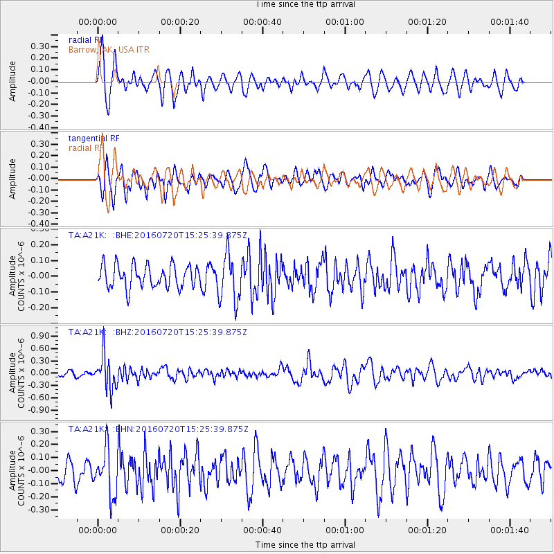
A21K Barrow, AK, USA - Earthquake Result Viewer
*The percent match for this event was below the threshold and hence no stack was calculated.
| Earthquake location: |
Vanuatu Islands |
| Earthquake latitude/longitude: |
-18.9/169.0 |
| Earthquake time(UTC): |
2016/07/20 (202) 15:13:16 GMT |
| Earthquake Depth: |
164 km |
| Earthquake Magnitude: |
6.0 MO |
| Earthquake Catalog/Contributor: |
NEIC PDE/NEIC ALERT |
|
| Network: |
TA USArray Transportable Network (new EarthScope stations) |
| Station: |
A21K Barrow, AK, USA |
| Lat/Lon: |
71.32 N/156.62 W |
| Elevation: |
577 m |
|
| Distance: |
93.0 deg |
| Az: |
10.49 deg |
| Baz: |
212.344 deg |
| Ray Param: |
$rayparam |
*The percent match for this event was below the threshold and hence was not used in the summary stack. |
|
| Radial Match: |
66.98406 % |
| Radial Bump: |
400 |
| Transverse Match: |
62.28713 % |
| Transverse Bump: |
400 |
| SOD ConfigId: |
11737051 |
| Insert Time: |
2019-04-25 02:58:36.475 +0000 |
| GWidth: |
2.5 |
| Max Bumps: |
400 |
| Tol: |
0.001 |
|
Signal To Noise
| Channel | StoN | STA | LTA |
| TA:A21K: :BHZ:20160720T15:25:39.875Z | 6.865175 | 4.1848318E-7 | 6.09574E-8 |
| TA:A21K: :BHN:20160720T15:25:39.875Z | 2.3737211 | 1.8566793E-7 | 7.821809E-8 |
| TA:A21K: :BHE:20160720T15:25:39.875Z | 2.1386933 | 1.5145372E-7 | 7.081601E-8 |
| Arrivals |
| Ps | |
| PpPs | |
| PsPs/PpSs | |


