You are here: Home > Network List > TA - USArray Transportable Network (new EarthScope stations) Stations List
> Station F21K Alatna River, AK, USA > Earthquake Result Viewer
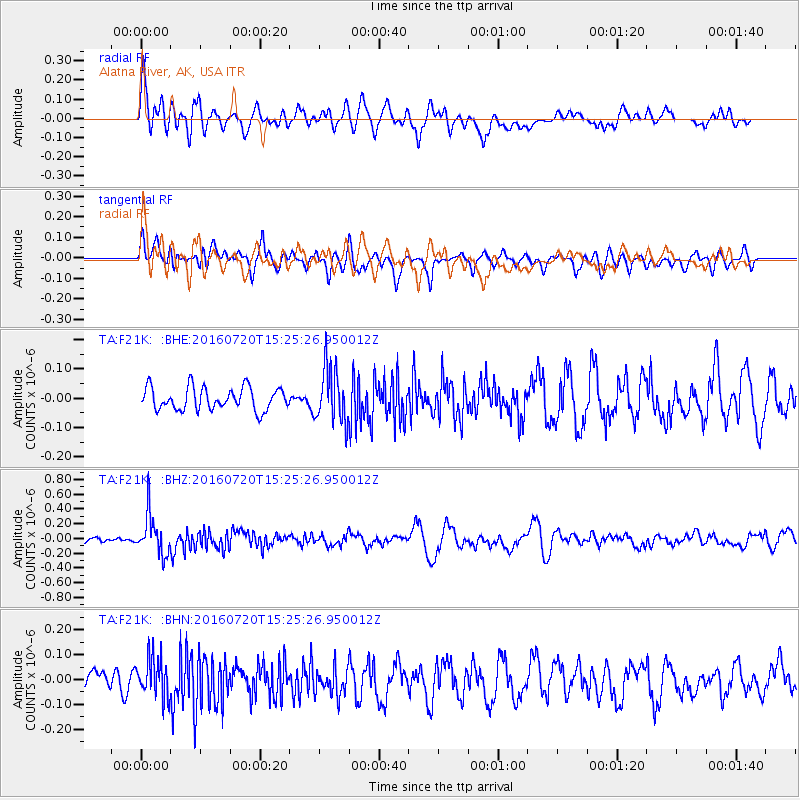
F21K Alatna River, AK, USA - Earthquake Result Viewer
*The percent match for this event was below the threshold and hence no stack was calculated.
| Earthquake location: |
Vanuatu Islands |
| Earthquake latitude/longitude: |
-18.9/169.0 |
| Earthquake time(UTC): |
2016/07/20 (202) 15:13:16 GMT |
| Earthquake Depth: |
164 km |
| Earthquake Magnitude: |
6.0 MO |
| Earthquake Catalog/Contributor: |
NEIC PDE/NEIC ALERT |
|
| Network: |
TA USArray Transportable Network (new EarthScope stations) |
| Station: |
F21K Alatna River, AK, USA |
| Lat/Lon: |
67.22 N/153.48 W |
| Elevation: |
597 m |
|
| Distance: |
90.2 deg |
| Az: |
13.708 deg |
| Baz: |
215.183 deg |
| Ray Param: |
$rayparam |
*The percent match for this event was below the threshold and hence was not used in the summary stack. |
|
| Radial Match: |
69.6656 % |
| Radial Bump: |
400 |
| Transverse Match: |
56.914528 % |
| Transverse Bump: |
400 |
| SOD ConfigId: |
11737051 |
| Insert Time: |
2019-04-25 02:58:46.895 +0000 |
| GWidth: |
2.5 |
| Max Bumps: |
400 |
| Tol: |
0.001 |
|
Signal To Noise
| Channel | StoN | STA | LTA |
| TA:F21K: :BHZ:20160720T15:25:26.950012Z | 6.708807 | 2.69036E-7 | 4.0101916E-8 |
| TA:F21K: :BHN:20160720T15:25:26.950012Z | 1.8436668 | 7.951623E-8 | 4.3129393E-8 |
| TA:F21K: :BHE:20160720T15:25:26.950012Z | 2.3819797 | 9.172057E-8 | 3.8506023E-8 |
| Arrivals |
| Ps | |
| PpPs | |
| PsPs/PpSs | |


