You are here: Home > Network List > TA - USArray Transportable Network (new EarthScope stations) Stations List
> Station L19K White Mountain, AK, USA > Earthquake Result Viewer
L19K White Mountain, AK, USA - Earthquake Result Viewer

| Earthquake location: |
Vanuatu Islands |
| Earthquake latitude/longitude: |
-18.9/169.0 |
| Earthquake time(UTC): |
2016/07/20 (202) 15:13:16 GMT |
| Earthquake Depth: |
164 km |
| Earthquake Magnitude: |
6.0 MO |
| Earthquake Catalog/Contributor: |
NEIC PDE/NEIC ALERT |
|
| Network: |
TA USArray Transportable Network (new EarthScope stations) |
| Station: |
L19K White Mountain, AK, USA |
| Lat/Lon: |
62.18 N/154.85 W |
| Elevation: |
650 m |
|
| Distance: |
85.7 deg |
| Az: |
16.098 deg |
| Baz: |
214.028 deg |
| Ray Param: |
0.04418269 |
| Estimated Moho Depth: |
69.75 km |
| Estimated Crust Vp/Vs: |
1.76 |
| Assumed Crust Vp: |
6.438 km/s |
| Estimated Crust Vs: |
3.653 km/s |
| Estimated Crust Poisson's Ratio: |
0.26 |
|
| Radial Match: |
80.86719 % |
| Radial Bump: |
400 |
| Transverse Match: |
73.209145 % |
| Transverse Bump: |
400 |
| SOD ConfigId: |
11737051 |
| Insert Time: |
2019-04-25 02:59:16.379 +0000 |
| GWidth: |
2.5 |
| Max Bumps: |
400 |
| Tol: |
0.001 |
|
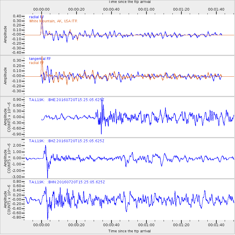
Signal To Noise
| Channel | StoN | STA | LTA |
| TA:L19K: :BHZ:20160720T15:25:05.625Z | 15.148494 | 1.0953455E-6 | 7.230722E-8 |
| TA:L19K: :BHN:20160720T15:25:05.625Z | 5.564864 | 3.257116E-7 | 5.853002E-8 |
| TA:L19K: :BHE:20160720T15:25:05.625Z | 3.8670375 | 2.7230365E-7 | 7.0416604E-8 |
| Arrivals |
| Ps | 8.5 SECOND |
| PpPs | 29 SECOND |
| PsPs/PpSs | 38 SECOND |


