You are here: Home > Network List > TA - USArray Transportable Network (new EarthScope stations) Stations List
> Station M19K Big River Lodge, Big River, AK, USA > Earthquake Result Viewer
M19K Big River Lodge, Big River, AK, USA - Earthquake Result Viewer
| Earthquake location: |
Vanuatu Islands |
| Earthquake latitude/longitude: |
-18.9/169.0 |
| Earthquake time(UTC): |
2016/07/20 (202) 15:13:16 GMT |
| Earthquake Depth: |
164 km |
| Earthquake Magnitude: |
6.0 MO |
| Earthquake Catalog/Contributor: |
NEIC PDE/NEIC ALERT |
|
| Network: |
TA USArray Transportable Network (new EarthScope stations) |
| Station: |
M19K Big River Lodge, Big River, AK, USA |
| Lat/Lon: |
61.90 N/154.39 W |
| Elevation: |
521 m |
|
| Distance: |
85.6 deg |
| Az: |
16.436 deg |
| Baz: |
214.461 deg |
| Ray Param: |
0.044258475 |
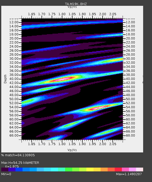
| Estimated Moho Depth: |
54.25 km |
| Estimated Crust Vp/Vs: |
1.98 |
| Assumed Crust Vp: |
6.566 km/s |
| Estimated Crust Vs: |
3.325 km/s |
| Estimated Crust Poisson's Ratio: |
0.33 |
|
| Radial Match: |
84.130905 % |
| Radial Bump: |
400 |
| Transverse Match: |
75.79454 % |
| Transverse Bump: |
400 |
| SOD ConfigId: |
11737051 |
| Insert Time: |
2019-04-25 02:59:17.741 +0000 |
| GWidth: |
2.5 |
| Max Bumps: |
400 |
| Tol: |
0.001 |
|

Signal To Noise
| Channel | StoN | STA | LTA |
| TA:M19K: :BHZ:20160720T15:25:05.099976Z | 10.521329 | 9.0184824E-7 | 8.5716195E-8 |
| TA:M19K: :BHN:20160720T15:25:05.099976Z | 3.926582 | 2.7869757E-7 | 7.0977144E-8 |
| TA:M19K: :BHE:20160720T15:25:05.099976Z | 3.6337492 | 2.0966876E-7 | 5.7700394E-8 |
| Arrivals |
| Ps | 8.2 SECOND |
| PpPs | 24 SECOND |
| PsPs/PpSs | 32 SECOND |


