You are here: Home > Network List > TA - USArray Transportable Network (new EarthScope stations) Stations List
> Station N16K Nishlik Lake, AK, USA > Earthquake Result Viewer
N16K Nishlik Lake, AK, USA - Earthquake Result Viewer
| Earthquake location: |
Vanuatu Islands |
| Earthquake latitude/longitude: |
-18.9/169.0 |
| Earthquake time(UTC): |
2016/07/20 (202) 15:13:16 GMT |
| Earthquake Depth: |
164 km |
| Earthquake Magnitude: |
6.0 MO |
| Earthquake Catalog/Contributor: |
NEIC PDE/NEIC ALERT |
|
| Network: |
TA USArray Transportable Network (new EarthScope stations) |
| Station: |
N16K Nishlik Lake, AK, USA |
| Lat/Lon: |
60.47 N/158.77 W |
| Elevation: |
582 m |
|
| Distance: |
83.3 deg |
| Az: |
15.414 deg |
| Baz: |
210.532 deg |
| Ray Param: |
0.04591513 |
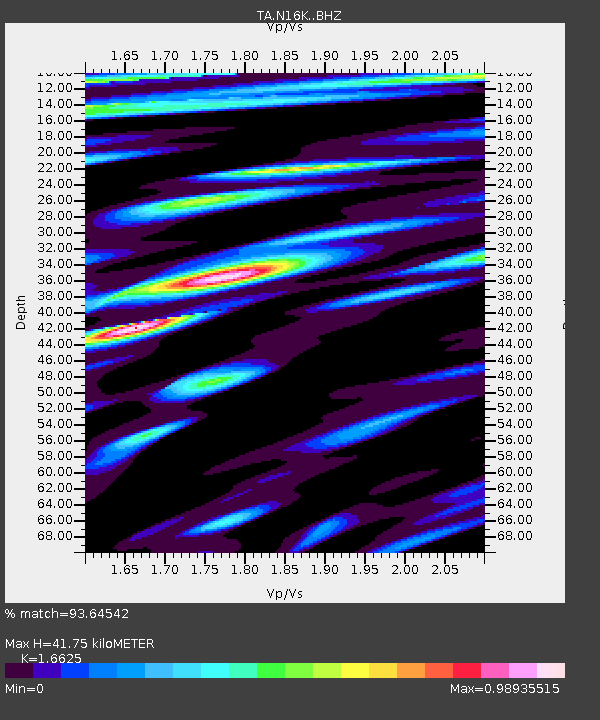
| Estimated Moho Depth: |
41.75 km |
| Estimated Crust Vp/Vs: |
1.66 |
| Assumed Crust Vp: |
6.276 km/s |
| Estimated Crust Vs: |
3.775 km/s |
| Estimated Crust Poisson's Ratio: |
0.22 |
|
| Radial Match: |
93.64542 % |
| Radial Bump: |
400 |
| Transverse Match: |
75.81957 % |
| Transverse Bump: |
400 |
| SOD ConfigId: |
11737051 |
| Insert Time: |
2019-04-25 02:59:26.235 +0000 |
| GWidth: |
2.5 |
| Max Bumps: |
400 |
| Tol: |
0.001 |
|

Signal To Noise
| Channel | StoN | STA | LTA |
| TA:N16K: :BHZ:20160720T15:24:53.375Z | 23.419546 | 1.8906869E-6 | 8.073115E-8 |
| TA:N16K: :BHN:20160720T15:24:53.375Z | 7.1824465 | 5.38982E-7 | 7.504156E-8 |
| TA:N16K: :BHE:20160720T15:24:53.375Z | 5.739577 | 4.9529535E-7 | 8.6294754E-8 |
| Arrivals |
| Ps | 4.5 SECOND |
| PpPs | 17 SECOND |
| PsPs/PpSs | 22 SECOND |


