You are here: Home > Network List > UW - Pacific Northwest Regional Seismic Network Stations List
> Station PASS Maple Falls, WA, USA > Earthquake Result Viewer
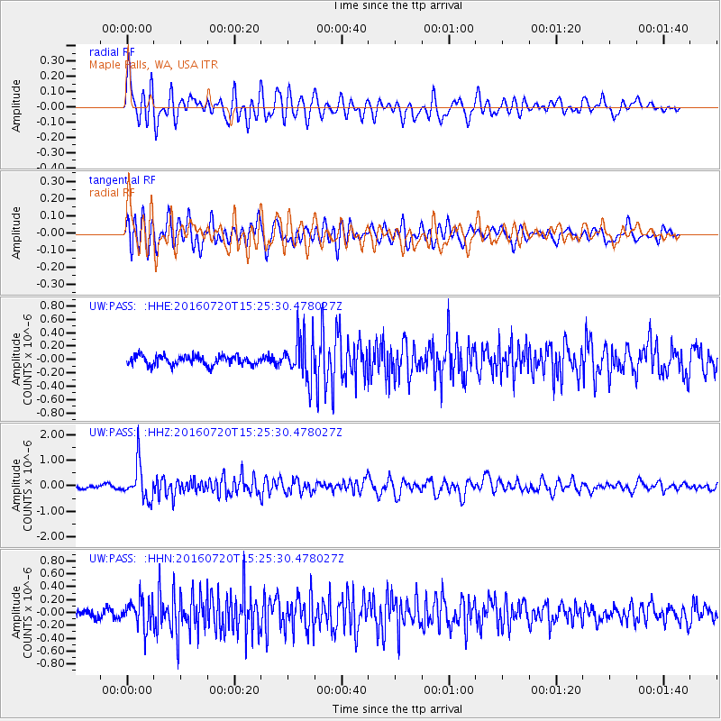
PASS Maple Falls, WA, USA - Earthquake Result Viewer
*The percent match for this event was below the threshold and hence no stack was calculated.
| Earthquake location: |
Vanuatu Islands |
| Earthquake latitude/longitude: |
-18.9/169.0 |
| Earthquake time(UTC): |
2016/07/20 (202) 15:13:16 GMT |
| Earthquake Depth: |
164 km |
| Earthquake Magnitude: |
6.0 MO |
| Earthquake Catalog/Contributor: |
NEIC PDE/NEIC ALERT |
|
| Network: |
UW Pacific Northwest Regional Seismic Network |
| Station: |
PASS Maple Falls, WA, USA |
| Lat/Lon: |
49.00 N/122.09 W |
| Elevation: |
174 m |
|
| Distance: |
91.0 deg |
| Az: |
37.913 deg |
| Baz: |
242.046 deg |
| Ray Param: |
$rayparam |
*The percent match for this event was below the threshold and hence was not used in the summary stack. |
|
| Radial Match: |
72.61473 % |
| Radial Bump: |
400 |
| Transverse Match: |
64.196205 % |
| Transverse Bump: |
400 |
| SOD ConfigId: |
11737051 |
| Insert Time: |
2019-04-25 03:00:36.210 +0000 |
| GWidth: |
2.5 |
| Max Bumps: |
400 |
| Tol: |
0.001 |
|
Signal To Noise
| Channel | StoN | STA | LTA |
| UW:PASS: :HHZ:20160720T15:25:30.478027Z | 9.845668 | 7.089174E-7 | 7.200298E-8 |
| UW:PASS: :HHN:20160720T15:25:30.478027Z | 3.87995 | 2.2219415E-7 | 5.726727E-8 |
| UW:PASS: :HHE:20160720T15:25:30.478027Z | 4.5932946 | 3.179887E-7 | 6.9228896E-8 |
| Arrivals |
| Ps | |
| PpPs | |
| PsPs/PpSs | |


