You are here: Home > Network List > US - United States National Seismic Network Stations List
> Station HAWA Hanford, Washington, USA > Earthquake Result Viewer
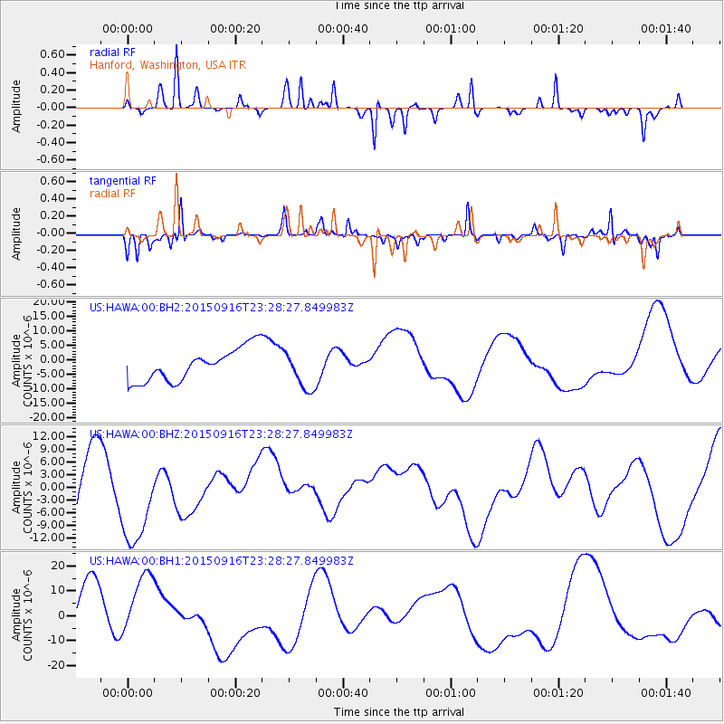
HAWA Hanford, Washington, USA - Earthquake Result Viewer
*The percent match for this event was below the threshold and hence no stack was calculated.
| Earthquake location: |
Near Coast Of Central Chile |
| Earthquake latitude/longitude: |
-31.6/-71.9 |
| Earthquake time(UTC): |
2015/09/16 (259) 23:16:05 GMT |
| Earthquake Depth: |
10 km |
| Earthquake Magnitude: |
6.2 MB |
| Earthquake Catalog/Contributor: |
NEIC PDE/NEIC COMCAT |
|
| Network: |
US United States National Seismic Network |
| Station: |
HAWA Hanford, Washington, USA |
| Lat/Lon: |
46.39 N/119.53 W |
| Elevation: |
364 m |
|
| Distance: |
88.7 deg |
| Az: |
329.241 deg |
| Baz: |
140.907 deg |
| Ray Param: |
$rayparam |
*The percent match for this event was below the threshold and hence was not used in the summary stack. |
|
| Radial Match: |
79.09279 % |
| Radial Bump: |
202 |
| Transverse Match: |
53.408363 % |
| Transverse Bump: |
228 |
| SOD ConfigId: |
1156111 |
| Insert Time: |
2015-10-01 00:01:07.007 +0000 |
| GWidth: |
2.5 |
| Max Bumps: |
400 |
| Tol: |
0.001 |
|
Signal To Noise
| Channel | StoN | STA | LTA |
| US:HAWA:00:BHZ:20150916T23:28:27.849983Z | 1.1206832 | 1.2615496E-5 | 1.1256969E-5 |
| US:HAWA:00:BH1:20150916T23:28:27.849983Z | 1.1781062 | 1.3008714E-5 | 1.1042056E-5 |
| US:HAWA:00:BH2:20150916T23:28:27.849983Z | 1.1809152 | 6.6158636E-6 | 5.602319E-6 |
| Arrivals |
| Ps | |
| PpPs | |
| PsPs/PpSs | |


