You are here: Home > Network List > CI - Caltech Regional Seismic Network Stations List
> Station BFS Mt Baldy Forest Station > Earthquake Result Viewer
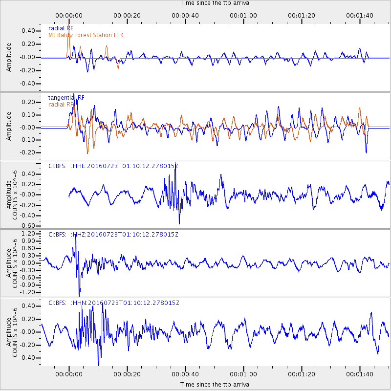
BFS Mt Baldy Forest Station - Earthquake Result Viewer
*The percent match for this event was below the threshold and hence no stack was calculated.
| Earthquake location: |
Northwest Of Kuril Islands |
| Earthquake latitude/longitude: |
47.7/147.0 |
| Earthquake time(UTC): |
2016/07/23 (205) 01:00:21 GMT |
| Earthquake Depth: |
407 km |
| Earthquake Magnitude: |
5.7 MB |
| Earthquake Catalog/Contributor: |
NEIC PDE/NEIC ALERT |
|
| Network: |
CI Caltech Regional Seismic Network |
| Station: |
BFS Mt Baldy Forest Station |
| Lat/Lon: |
34.24 N/117.66 W |
| Elevation: |
1312 m |
|
| Distance: |
68.9 deg |
| Az: |
62.158 deg |
| Baz: |
313.874 deg |
| Ray Param: |
$rayparam |
*The percent match for this event was below the threshold and hence was not used in the summary stack. |
|
| Radial Match: |
63.39219 % |
| Radial Bump: |
400 |
| Transverse Match: |
76.352394 % |
| Transverse Bump: |
400 |
| SOD ConfigId: |
11737051 |
| Insert Time: |
2019-04-25 03:06:54.001 +0000 |
| GWidth: |
2.5 |
| Max Bumps: |
400 |
| Tol: |
0.001 |
|
Signal To Noise
| Channel | StoN | STA | LTA |
| CI:BFS: :HHZ:20160723T01:10:12.278015Z | 3.0266652 | 5.565717E-7 | 1.8388943E-7 |
| CI:BFS: :HHN:20160723T01:10:12.278015Z | 1.0686535 | 1.5572658E-7 | 1.4572224E-7 |
| CI:BFS: :HHE:20160723T01:10:12.278015Z | 1.5624357 | 1.4848698E-7 | 9.5035574E-8 |
| Arrivals |
| Ps | |
| PpPs | |
| PsPs/PpSs | |


