You are here: Home > Network List > CI - Caltech Regional Seismic Network Stations List
> Station MPP McPhearson Peak > Earthquake Result Viewer
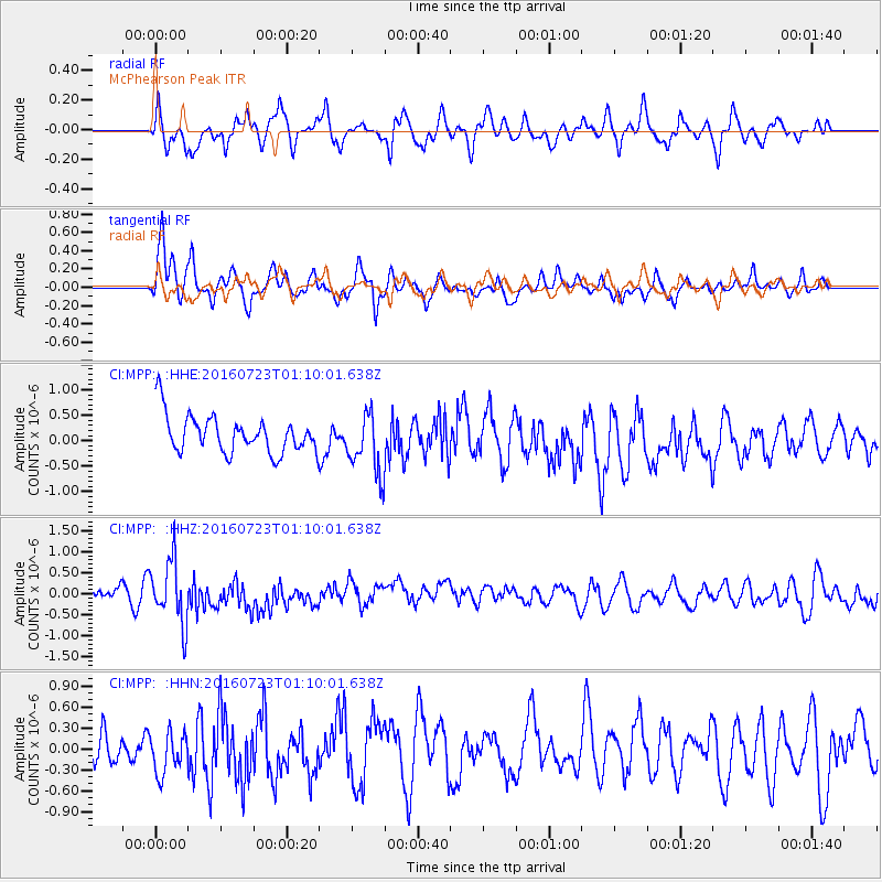
MPP McPhearson Peak - Earthquake Result Viewer
*The percent match for this event was below the threshold and hence no stack was calculated.
| Earthquake location: |
Northwest Of Kuril Islands |
| Earthquake latitude/longitude: |
47.7/147.0 |
| Earthquake time(UTC): |
2016/07/23 (205) 01:00:21 GMT |
| Earthquake Depth: |
407 km |
| Earthquake Magnitude: |
5.7 MB |
| Earthquake Catalog/Contributor: |
NEIC PDE/NEIC ALERT |
|
| Network: |
CI Caltech Regional Seismic Network |
| Station: |
MPP McPhearson Peak |
| Lat/Lon: |
34.89 N/119.81 W |
| Elevation: |
1739 m |
|
| Distance: |
67.1 deg |
| Az: |
62.968 deg |
| Baz: |
312.961 deg |
| Ray Param: |
$rayparam |
*The percent match for this event was below the threshold and hence was not used in the summary stack. |
|
| Radial Match: |
45.381317 % |
| Radial Bump: |
400 |
| Transverse Match: |
65.08069 % |
| Transverse Bump: |
400 |
| SOD ConfigId: |
11737051 |
| Insert Time: |
2019-04-25 03:07:16.894 +0000 |
| GWidth: |
2.5 |
| Max Bumps: |
400 |
| Tol: |
0.001 |
|
Signal To Noise
| Channel | StoN | STA | LTA |
| CI:MPP: :HHZ:20160723T01:10:01.638Z | 3.8271883 | 7.422292E-7 | 1.9393589E-7 |
| CI:MPP: :HHN:20160723T01:10:01.638Z | 1.2454904 | 3.4984728E-7 | 2.808912E-7 |
| CI:MPP: :HHE:20160723T01:10:01.638Z | 1.6301184 | 5.9950264E-7 | 3.6776632E-7 |
| Arrivals |
| Ps | |
| PpPs | |
| PsPs/PpSs | |


