You are here: Home > Network List > CN - Canadian National Seismograph Network Stations List
> Station LLLB Lillooet, BC, CA > Earthquake Result Viewer
LLLB Lillooet, BC, CA - Earthquake Result Viewer
*The percent match for this event was below the threshold and hence no stack was calculated.
| Earthquake location: |
Northwest Of Kuril Islands |
| Earthquake latitude/longitude: |
47.7/147.0 |
| Earthquake time(UTC): |
2016/07/23 (205) 01:00:21 GMT |
| Earthquake Depth: |
407 km |
| Earthquake Magnitude: |
5.7 MB |
| Earthquake Catalog/Contributor: |
NEIC PDE/NEIC ALERT |
|
| Network: |
CN Canadian National Seismograph Network |
| Station: |
LLLB Lillooet, BC, CA |
| Lat/Lon: |
50.61 N/121.88 W |
| Elevation: |
700 m |
|
| Distance: |
56.0 deg |
| Az: |
50.234 deg |
| Baz: |
305.434 deg |
| Ray Param: |
$rayparam |
*The percent match for this event was below the threshold and hence was not used in the summary stack. |
|
| Radial Match: |
41.89109 % |
| Radial Bump: |
400 |
| Transverse Match: |
43.482212 % |
| Transverse Bump: |
400 |
| SOD ConfigId: |
11737051 |
| Insert Time: |
2019-04-25 03:08:04.347 +0000 |
| GWidth: |
2.5 |
| Max Bumps: |
400 |
| Tol: |
0.001 |
|
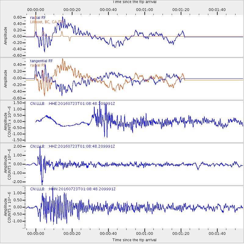
Signal To Noise
| Channel | StoN | STA | LTA |
| CN:LLLB: :HHZ:20160723T01:08:48.209991Z | 11.4113655 | 9.1282095E-7 | 7.999226E-8 |
| CN:LLLB: :HHN:20160723T01:08:48.209991Z | 10.325463 | 4.226068E-7 | 4.0928608E-8 |
| CN:LLLB: :HHE:20160723T01:08:48.209991Z | 1.7389965 | 4.651497E-7 | 2.6748168E-7 |
| Arrivals |
| Ps | |
| PpPs | |
| PsPs/PpSs | |


