You are here: Home > Network List > US - United States National Seismic Network Stations List
> Station CBKS Cedar Bluff, Kansas, USA > Earthquake Result Viewer
CBKS Cedar Bluff, Kansas, USA - Earthquake Result Viewer
| Earthquake location: |
Hokkaido, Japan Region |
| Earthquake latitude/longitude: |
42.9/144.9 |
| Earthquake time(UTC): |
2005/01/18 (018) 14:09:06 GMT |
| Earthquake Depth: |
42 km |
| Earthquake Magnitude: |
6.3 MB, 5.7 MS, 6.3 MW, 6.2 MW |
| Earthquake Catalog/Contributor: |
WHDF/NEIC |
|
| Network: |
US United States National Seismic Network |
| Station: |
CBKS Cedar Bluff, Kansas, USA |
| Lat/Lon: |
38.81 N/99.74 W |
| Elevation: |
677 m |
|
| Distance: |
79.8 deg |
| Az: |
45.82 deg |
| Baz: |
317.62 deg |
| Ray Param: |
0.048671048 |
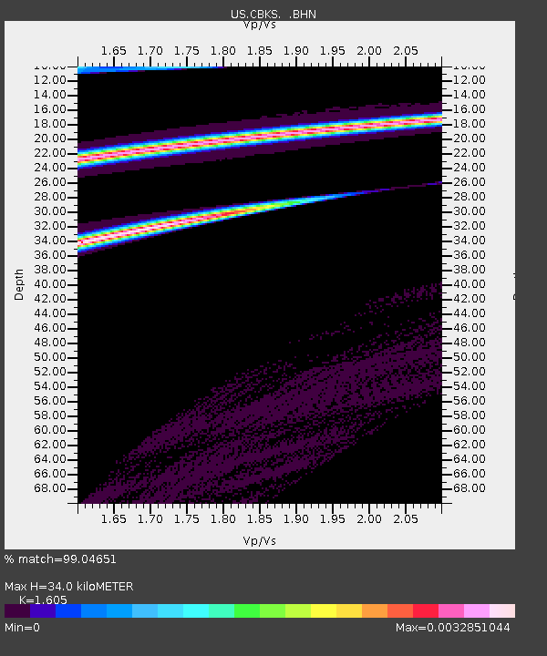
| Estimated Moho Depth: |
34.0 km |
| Estimated Crust Vp/Vs: |
1.61 |
| Assumed Crust Vp: |
6.483 km/s |
| Estimated Crust Vs: |
4.039 km/s |
| Estimated Crust Poisson's Ratio: |
0.18 |
|
| Radial Match: |
99.04651 % |
| Radial Bump: |
49 |
| Transverse Match: |
92.50778 % |
| Transverse Bump: |
89 |
| SOD ConfigId: |
110165 |
| Insert Time: |
2010-03-05 05:30:00.934 +0000 |
| GWidth: |
2.5 |
| Max Bumps: |
400 |
| Tol: |
0.001 |
|

Signal To Noise
| Channel | StoN | STA | LTA |
| US:CBKS: :BHN:20050118T14:20:38.818022Z | 0.92794055 | 5.3930843E-10 | 5.8118854E-10 |
| US:CBKS: :BHE:20050118T14:20:38.818022Z | 0.9450986 | 5.980365E-10 | 6.327769E-10 |
| US:CBKS: :BHZ:20050118T14:20:38.818022Z | 1.648223 | 7.5691436E-10 | 4.5923057E-10 |
| Arrivals |
| Ps | 3.3 SECOND |
| PpPs | 13 SECOND |
| PsPs/PpSs | 17 SECOND |


