You are here: Home > Network List > TA - USArray Transportable Network (new EarthScope stations) Stations List
> Station D23K Nanushuk River, AK USA > Earthquake Result Viewer
D23K Nanushuk River, AK USA - Earthquake Result Viewer
| Earthquake location: |
Northwest Of Kuril Islands |
| Earthquake latitude/longitude: |
47.7/147.0 |
| Earthquake time(UTC): |
2016/07/23 (205) 01:00:21 GMT |
| Earthquake Depth: |
407 km |
| Earthquake Magnitude: |
5.7 MB |
| Earthquake Catalog/Contributor: |
NEIC PDE/NEIC ALERT |
|
| Network: |
TA USArray Transportable Network (new EarthScope stations) |
| Station: |
D23K Nanushuk River, AK USA |
| Lat/Lon: |
68.97 N/150.68 W |
| Elevation: |
406 m |
|
| Distance: |
36.8 deg |
| Az: |
32.28 deg |
| Baz: |
267.524 deg |
| Ray Param: |
0.074706495 |
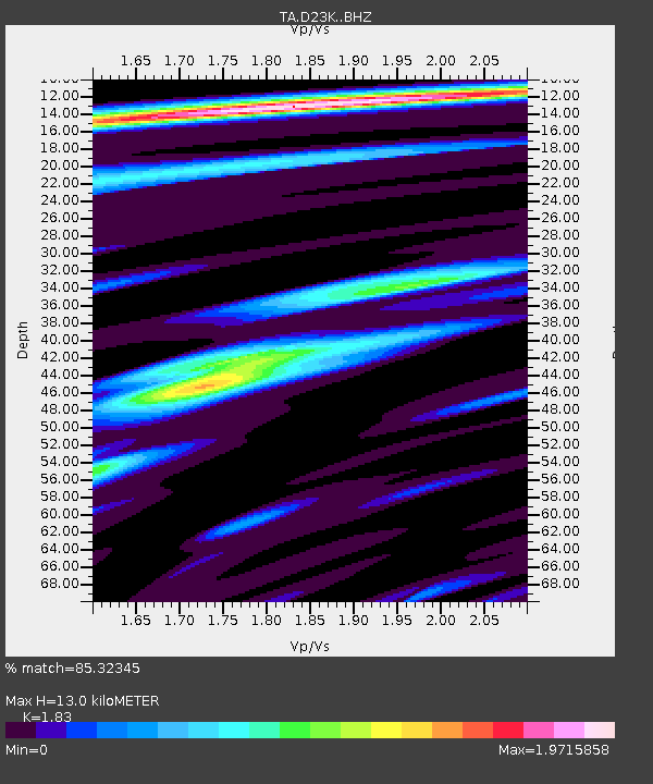
| Estimated Moho Depth: |
13.0 km |
| Estimated Crust Vp/Vs: |
1.83 |
| Assumed Crust Vp: |
6.221 km/s |
| Estimated Crust Vs: |
3.399 km/s |
| Estimated Crust Poisson's Ratio: |
0.29 |
|
| Radial Match: |
85.32345 % |
| Radial Bump: |
400 |
| Transverse Match: |
68.377464 % |
| Transverse Bump: |
400 |
| SOD ConfigId: |
11737051 |
| Insert Time: |
2019-04-25 03:15:29.898 +0000 |
| GWidth: |
2.5 |
| Max Bumps: |
400 |
| Tol: |
0.001 |
|
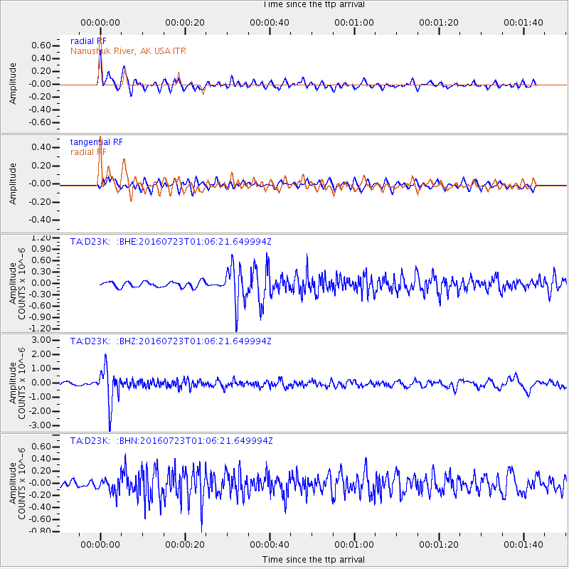
Signal To Noise
| Channel | StoN | STA | LTA |
| TA:D23K: :BHZ:20160723T01:06:21.649994Z | 12.406515 | 1.2634176E-6 | 1.0183501E-7 |
| TA:D23K: :BHN:20160723T01:06:21.649994Z | 1.7295438 | 1.1905702E-7 | 6.883724E-8 |
| TA:D23K: :BHE:20160723T01:06:21.649994Z | 6.8311496 | 4.991842E-7 | 7.30747E-8 |
| Arrivals |
| Ps | 1.8 SECOND |
| PpPs | 5.5 SECOND |
| PsPs/PpSs | 7.4 SECOND |


