You are here: Home > Network List > TA - USArray Transportable Network (new EarthScope stations) Stations List
> Station H17A Grant Village (NPS), Yellowstone Nt. Park, WY, USA > Earthquake Result Viewer
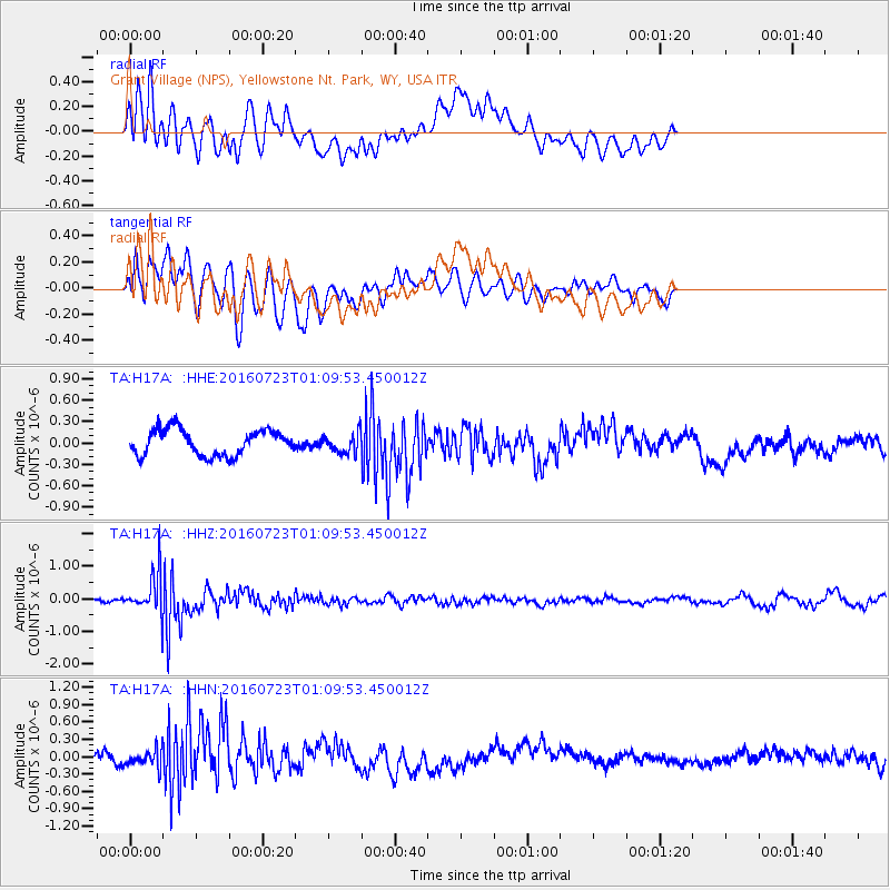
H17A Grant Village (NPS), Yellowstone Nt. Park, WY, USA - Earthquake Result Viewer
*The percent match for this event was below the threshold and hence no stack was calculated.
| Earthquake location: |
Northwest Of Kuril Islands |
| Earthquake latitude/longitude: |
47.7/147.0 |
| Earthquake time(UTC): |
2016/07/23 (205) 01:00:21 GMT |
| Earthquake Depth: |
407 km |
| Earthquake Magnitude: |
5.7 MB |
| Earthquake Catalog/Contributor: |
NEIC PDE/NEIC ALERT |
|
| Network: |
TA USArray Transportable Network (new EarthScope stations) |
| Station: |
H17A Grant Village (NPS), Yellowstone Nt. Park, WY, USA |
| Lat/Lon: |
44.40 N/110.58 W |
| Elevation: |
2400 m |
|
| Distance: |
65.8 deg |
| Az: |
50.11 deg |
| Baz: |
313.708 deg |
| Ray Param: |
$rayparam |
*The percent match for this event was below the threshold and hence was not used in the summary stack. |
|
| Radial Match: |
58.445316 % |
| Radial Bump: |
400 |
| Transverse Match: |
58.25617 % |
| Transverse Bump: |
400 |
| SOD ConfigId: |
11737051 |
| Insert Time: |
2019-04-25 03:15:47.790 +0000 |
| GWidth: |
2.5 |
| Max Bumps: |
400 |
| Tol: |
0.001 |
|
Signal To Noise
| Channel | StoN | STA | LTA |
| TA:H17A: :HHZ:20160723T01:09:53.450012Z | 11.169441 | 6.0894496E-7 | 5.4518836E-8 |
| TA:H17A: :HHN:20160723T01:09:53.450012Z | 0.9673381 | 1.4658657E-7 | 1.5153603E-7 |
| TA:H17A: :HHE:20160723T01:09:53.450012Z | 0.7645431 | 1.3743797E-7 | 1.7976483E-7 |
| Arrivals |
| Ps | |
| PpPs | |
| PsPs/PpSs | |


