You are here: Home > Network List > TA - USArray Transportable Network (new EarthScope stations) Stations List
> Station O17K Koliganek, Bristol Bay, AK, USA > Earthquake Result Viewer
O17K Koliganek, Bristol Bay, AK, USA - Earthquake Result Viewer
| Earthquake location: |
Northwest Of Kuril Islands |
| Earthquake latitude/longitude: |
47.7/147.0 |
| Earthquake time(UTC): |
2016/07/23 (205) 01:00:21 GMT |
| Earthquake Depth: |
407 km |
| Earthquake Magnitude: |
5.7 MB |
| Earthquake Catalog/Contributor: |
NEIC PDE/NEIC ALERT |
|
| Network: |
TA USArray Transportable Network (new EarthScope stations) |
| Station: |
O17K Koliganek, Bristol Bay, AK, USA |
| Lat/Lon: |
59.77 N/157.09 W |
| Elevation: |
156 m |
|
| Distance: |
34.2 deg |
| Az: |
48.288 deg |
| Baz: |
274.797 deg |
| Ray Param: |
0.07616141 |
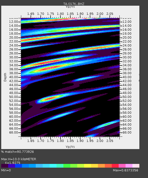
| Estimated Moho Depth: |
10.0 km |
| Estimated Crust Vp/Vs: |
1.93 |
| Assumed Crust Vp: |
6.276 km/s |
| Estimated Crust Vs: |
3.256 km/s |
| Estimated Crust Poisson's Ratio: |
0.32 |
|
| Radial Match: |
90.773926 % |
| Radial Bump: |
400 |
| Transverse Match: |
72.053894 % |
| Transverse Bump: |
400 |
| SOD ConfigId: |
11737051 |
| Insert Time: |
2019-04-25 03:16:33.081 +0000 |
| GWidth: |
2.5 |
| Max Bumps: |
400 |
| Tol: |
0.001 |
|
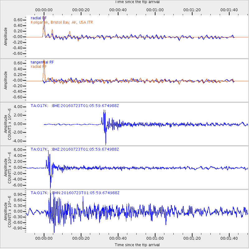
Signal To Noise
| Channel | StoN | STA | LTA |
| TA:O17K: :BHZ:20160723T01:05:59.674988Z | 29.916761 | 2.245197E-6 | 7.504813E-8 |
| TA:O17K: :BHN:20160723T01:05:59.674988Z | 3.1124692 | 2.801453E-7 | 9.000741E-8 |
| TA:O17K: :BHE:20160723T01:05:59.674988Z | 20.452461 | 1.3696982E-6 | 6.696985E-8 |
| Arrivals |
| Ps | 1.6 SECOND |
| PpPs | 4.4 SECOND |
| PsPs/PpSs | 6.0 SECOND |


