You are here: Home > Network List > TA - USArray Transportable Network (new EarthScope stations) Stations List
> Station O19K Port Alsworth, AK, USA > Earthquake Result Viewer
O19K Port Alsworth, AK, USA - Earthquake Result Viewer
| Earthquake location: |
Northwest Of Kuril Islands |
| Earthquake latitude/longitude: |
47.7/147.0 |
| Earthquake time(UTC): |
2016/07/23 (205) 01:00:21 GMT |
| Earthquake Depth: |
407 km |
| Earthquake Magnitude: |
5.7 MB |
| Earthquake Catalog/Contributor: |
NEIC PDE/NEIC ALERT |
|
| Network: |
TA USArray Transportable Network (new EarthScope stations) |
| Station: |
O19K Port Alsworth, AK, USA |
| Lat/Lon: |
60.20 N/154.32 W |
| Elevation: |
96 m |
|
| Distance: |
35.5 deg |
| Az: |
47.313 deg |
| Baz: |
276.395 deg |
| Ray Param: |
0.0754208 |
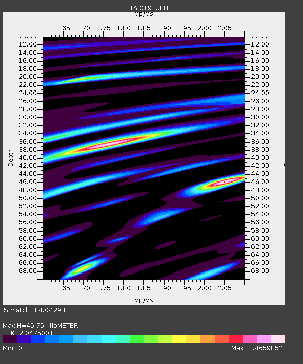
| Estimated Moho Depth: |
45.75 km |
| Estimated Crust Vp/Vs: |
2.05 |
| Assumed Crust Vp: |
6.566 km/s |
| Estimated Crust Vs: |
3.207 km/s |
| Estimated Crust Poisson's Ratio: |
0.34 |
|
| Radial Match: |
84.04298 % |
| Radial Bump: |
400 |
| Transverse Match: |
59.773315 % |
| Transverse Bump: |
400 |
| SOD ConfigId: |
11737051 |
| Insert Time: |
2019-04-25 03:16:33.575 +0000 |
| GWidth: |
2.5 |
| Max Bumps: |
400 |
| Tol: |
0.001 |
|

Signal To Noise
| Channel | StoN | STA | LTA |
| TA:O19K: :BHZ:20160723T01:06:11.000Z | 2.348304 | 1.0402528E-6 | 4.4298045E-7 |
| TA:O19K: :BHN:20160723T01:06:11.000Z | 1.2451414 | 3.2617336E-7 | 2.619569E-7 |
| TA:O19K: :BHE:20160723T01:06:11.000Z | 3.0864336 | 9.549253E-7 | 3.093944E-7 |
| Arrivals |
| Ps | 7.8 SECOND |
| PpPs | 20 SECOND |
| PsPs/PpSs | 28 SECOND |


