You are here: Home > Network List > TA - USArray Transportable Network (new EarthScope stations) Stations List
> Station P17K Kvichak River, AK, USA > Earthquake Result Viewer
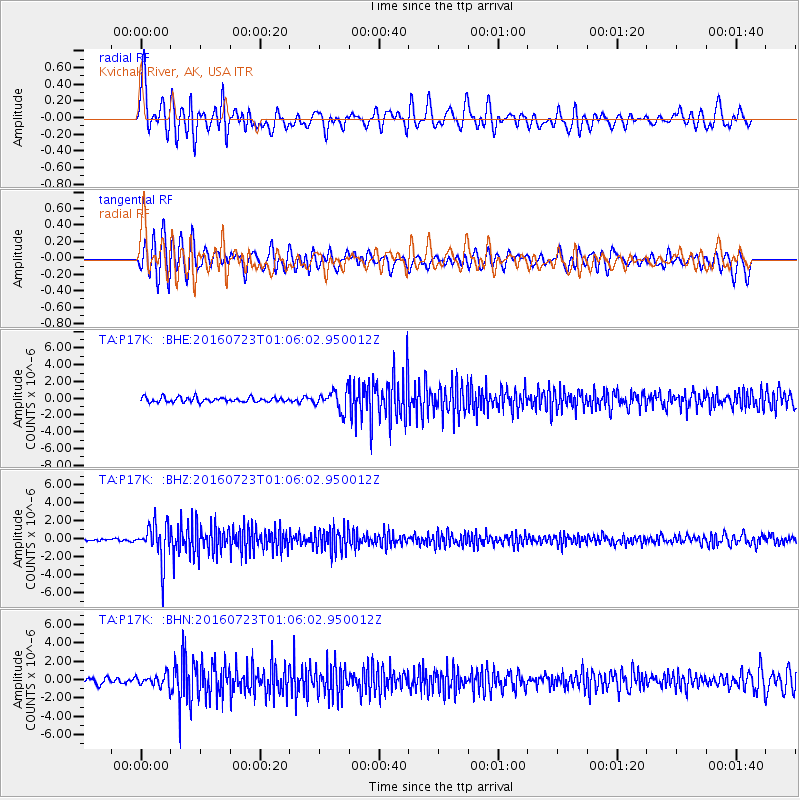
P17K Kvichak River, AK, USA - Earthquake Result Viewer
*The percent match for this event was below the threshold and hence no stack was calculated.
| Earthquake location: |
Northwest Of Kuril Islands |
| Earthquake latitude/longitude: |
47.7/147.0 |
| Earthquake time(UTC): |
2016/07/23 (205) 01:00:21 GMT |
| Earthquake Depth: |
407 km |
| Earthquake Magnitude: |
5.7 MB |
| Earthquake Catalog/Contributor: |
NEIC PDE/NEIC ALERT |
|
| Network: |
TA USArray Transportable Network (new EarthScope stations) |
| Station: |
P17K Kvichak River, AK, USA |
| Lat/Lon: |
59.20 N/156.44 W |
| Elevation: |
91 m |
|
| Distance: |
34.6 deg |
| Az: |
49.254 deg |
| Baz: |
276.158 deg |
| Ray Param: |
$rayparam |
*The percent match for this event was below the threshold and hence was not used in the summary stack. |
|
| Radial Match: |
77.2025 % |
| Radial Bump: |
400 |
| Transverse Match: |
73.48034 % |
| Transverse Bump: |
400 |
| SOD ConfigId: |
11737051 |
| Insert Time: |
2019-04-25 03:16:41.481 +0000 |
| GWidth: |
2.5 |
| Max Bumps: |
400 |
| Tol: |
0.001 |
|
Signal To Noise
| Channel | StoN | STA | LTA |
| TA:P17K: :BHZ:20160723T01:06:02.950012Z | 17.855515 | 2.0719203E-6 | 1.1603812E-7 |
| TA:P17K: :BHN:20160723T01:06:02.950012Z | 1.9519681 | 6.2721546E-7 | 3.2132465E-7 |
| TA:P17K: :BHE:20160723T01:06:02.950012Z | 3.940757 | 1.1416782E-6 | 2.8971039E-7 |
| Arrivals |
| Ps | |
| PpPs | |
| PsPs/PpSs | |


