You are here: Home > Network List > TA - USArray Transportable Network (new EarthScope stations) Stations List
> Station R17K Ugashik Creek, AK, USA > Earthquake Result Viewer
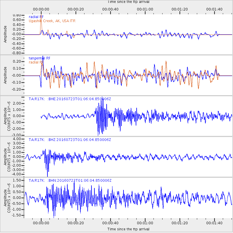
R17K Ugashik Creek, AK, USA - Earthquake Result Viewer
*The percent match for this event was below the threshold and hence no stack was calculated.
| Earthquake location: |
Northwest Of Kuril Islands |
| Earthquake latitude/longitude: |
47.7/147.0 |
| Earthquake time(UTC): |
2016/07/23 (205) 01:00:21 GMT |
| Earthquake Depth: |
407 km |
| Earthquake Magnitude: |
5.7 MB |
| Earthquake Catalog/Contributor: |
NEIC PDE/NEIC ALERT |
|
| Network: |
TA USArray Transportable Network (new EarthScope stations) |
| Station: |
R17K Ugashik Creek, AK, USA |
| Lat/Lon: |
57.64 N/156.39 W |
| Elevation: |
273 m |
|
| Distance: |
34.8 deg |
| Az: |
51.969 deg |
| Baz: |
278.435 deg |
| Ray Param: |
$rayparam |
*The percent match for this event was below the threshold and hence was not used in the summary stack. |
|
| Radial Match: |
56.956257 % |
| Radial Bump: |
400 |
| Transverse Match: |
54.64449 % |
| Transverse Bump: |
400 |
| SOD ConfigId: |
11737051 |
| Insert Time: |
2019-04-25 03:16:52.896 +0000 |
| GWidth: |
2.5 |
| Max Bumps: |
400 |
| Tol: |
0.001 |
|
Signal To Noise
| Channel | StoN | STA | LTA |
| TA:R17K: :BHZ:20160723T01:06:04.850006Z | 4.642712 | 1.3935788E-6 | 3.0016483E-7 |
| TA:R17K: :BHN:20160723T01:06:04.850006Z | 1.556077 | 4.1036543E-7 | 2.6371794E-7 |
| TA:R17K: :BHE:20160723T01:06:04.850006Z | 6.154703 | 1.1840574E-6 | 1.9238253E-7 |
| Arrivals |
| Ps | |
| PpPs | |
| PsPs/PpSs | |


