You are here: Home > Network List > US - United States National Seismic Network Stations List
> Station CBKS Cedar Bluff, Kansas, USA > Earthquake Result Viewer
CBKS Cedar Bluff, Kansas, USA - Earthquake Result Viewer

| Earthquake location: |
Costa Rica |
| Earthquake latitude/longitude: |
9.0/-84.2 |
| Earthquake time(UTC): |
1999/08/20 (232) 10:02:21 GMT |
| Earthquake Depth: |
20 km |
| Earthquake Magnitude: |
6.1 MB, 6.9 MS, 7.0 MW, 6.1 ML |
| Earthquake Catalog/Contributor: |
WHDF/NEIC |
|
| Network: |
US United States National Seismic Network |
| Station: |
CBKS Cedar Bluff, Kansas, USA |
| Lat/Lon: |
38.81 N/99.74 W |
| Elevation: |
677 m |
|
| Distance: |
32.8 deg |
| Az: |
337.198 deg |
| Baz: |
150.66 deg |
| Ray Param: |
0.078488074 |
| Estimated Moho Depth: |
29.5 km |
| Estimated Crust Vp/Vs: |
2.10 |
| Assumed Crust Vp: |
6.483 km/s |
| Estimated Crust Vs: |
3.091 km/s |
| Estimated Crust Poisson's Ratio: |
0.35 |
|
| Radial Match: |
95.34951 % |
| Radial Bump: |
369 |
| Transverse Match: |
73.79045 % |
| Transverse Bump: |
400 |
| SOD ConfigId: |
110177 |
| Insert Time: |
2010-03-05 05:31:14.021 +0000 |
| GWidth: |
2.5 |
| Max Bumps: |
400 |
| Tol: |
0.001 |
|
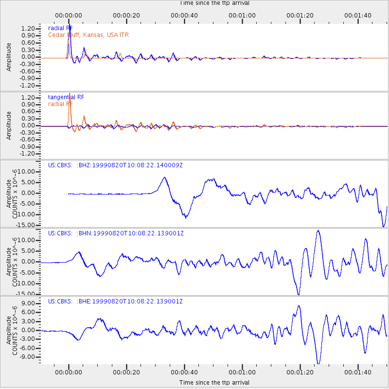
Signal To Noise
| Channel | StoN | STA | LTA |
| US:CBKS: :BHN:19990820T10:08:22.139001Z | 34.443817 | 2.7791398E-6 | 8.068618E-8 |
| US:CBKS: :BHE:19990820T10:08:22.139001Z | 17.40038 | 1.846114E-6 | 1.0609619E-7 |
| US:CBKS: :BHZ:19990820T10:08:22.140009Z | 67.618454 | 4.612689E-6 | 6.821642E-8 |
| Arrivals |
| Ps | 5.3 SECOND |
| PpPs | 13 SECOND |
| PsPs/PpSs | 19 SECOND |


