You are here: Home > Network List > US - United States National Seismic Network Stations List
> Station CBKS Cedar Bluff, Kansas, USA > Earthquake Result Viewer
CBKS Cedar Bluff, Kansas, USA - Earthquake Result Viewer
| Earthquake location: |
Off Coast Of Southern Chile |
| Earthquake latitude/longitude: |
-40.5/-74.8 |
| Earthquake time(UTC): |
1999/08/22 (234) 09:35:39 GMT |
| Earthquake Depth: |
33 km |
| Earthquake Magnitude: |
6.2 MB, 5.8 MS, 6.4 MW, 6.2 MW |
| Earthquake Catalog/Contributor: |
WHDF/NEIC |
|
| Network: |
US United States National Seismic Network |
| Station: |
CBKS Cedar Bluff, Kansas, USA |
| Lat/Lon: |
38.81 N/99.74 W |
| Elevation: |
677 m |
|
| Distance: |
82.2 deg |
| Az: |
340.547 deg |
| Baz: |
161.033 deg |
| Ray Param: |
0.047020476 |
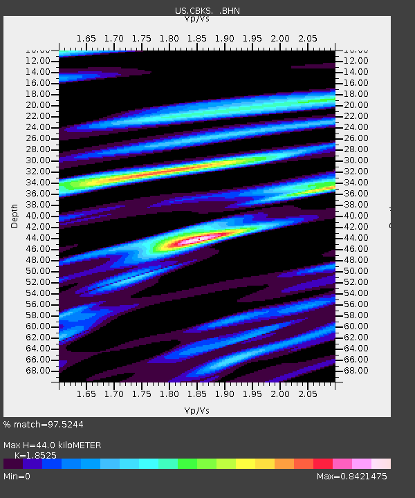
| Estimated Moho Depth: |
44.0 km |
| Estimated Crust Vp/Vs: |
1.85 |
| Assumed Crust Vp: |
6.483 km/s |
| Estimated Crust Vs: |
3.499 km/s |
| Estimated Crust Poisson's Ratio: |
0.29 |
|
| Radial Match: |
97.5244 % |
| Radial Bump: |
303 |
| Transverse Match: |
85.65122 % |
| Transverse Bump: |
400 |
| SOD ConfigId: |
110177 |
| Insert Time: |
2010-03-05 05:31:16.103 +0000 |
| GWidth: |
2.5 |
| Max Bumps: |
400 |
| Tol: |
0.001 |
|

Signal To Noise
| Channel | StoN | STA | LTA |
| US:CBKS: :BHN:19990822T09:47:25.941008Z | 17.506834 | 1.8052236E-6 | 1.0311536E-7 |
| US:CBKS: :BHE:19990822T09:47:25.941008Z | 5.3877716 | 5.427699E-7 | 1.0074107E-7 |
| US:CBKS: :BHZ:19990822T09:47:25.941008Z | 66.27204 | 4.4678113E-6 | 6.741623E-8 |
| Arrivals |
| Ps | 5.9 SECOND |
| PpPs | 19 SECOND |
| PsPs/PpSs | 25 SECOND |


