You are here: Home > Network List > UW - Pacific Northwest Regional Seismic Network Stations List
> Station PASS Maple Falls, WA, USA > Earthquake Result Viewer
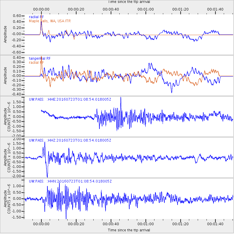
PASS Maple Falls, WA, USA - Earthquake Result Viewer
*The percent match for this event was below the threshold and hence no stack was calculated.
| Earthquake location: |
Northwest Of Kuril Islands |
| Earthquake latitude/longitude: |
47.7/147.0 |
| Earthquake time(UTC): |
2016/07/23 (205) 01:00:21 GMT |
| Earthquake Depth: |
407 km |
| Earthquake Magnitude: |
5.7 MB |
| Earthquake Catalog/Contributor: |
NEIC PDE/NEIC ALERT |
|
| Network: |
UW Pacific Northwest Regional Seismic Network |
| Station: |
PASS Maple Falls, WA, USA |
| Lat/Lon: |
49.00 N/122.09 W |
| Elevation: |
174 m |
|
| Distance: |
56.8 deg |
| Az: |
51.897 deg |
| Baz: |
306.199 deg |
| Ray Param: |
$rayparam |
*The percent match for this event was below the threshold and hence was not used in the summary stack. |
|
| Radial Match: |
64.62121 % |
| Radial Bump: |
400 |
| Transverse Match: |
56.580208 % |
| Transverse Bump: |
400 |
| SOD ConfigId: |
11737051 |
| Insert Time: |
2019-04-25 03:17:54.403 +0000 |
| GWidth: |
2.5 |
| Max Bumps: |
400 |
| Tol: |
0.001 |
|
Signal To Noise
| Channel | StoN | STA | LTA |
| UW:PASS: :HHZ:20160723T01:08:54.018005Z | 17.05801 | 8.85993E-7 | 5.1940003E-8 |
| UW:PASS: :HHN:20160723T01:08:54.018005Z | 5.6652966 | 3.8456153E-7 | 6.7880215E-8 |
| UW:PASS: :HHE:20160723T01:08:54.018005Z | 1.813008 | 4.137865E-7 | 2.2823203E-7 |
| Arrivals |
| Ps | |
| PpPs | |
| PsPs/PpSs | |


