You are here: Home > Network List > X614 - Homestake Gold Mine Three dimensional Broadband Array Stations List
> Station B4850 4850 level Homestake mine - near shaft 6 > Earthquake Result Viewer
B4850 4850 level Homestake mine - near shaft 6 - Earthquake Result Viewer
| Earthquake location: |
Northwest Of Kuril Islands |
| Earthquake latitude/longitude: |
47.7/147.0 |
| Earthquake time(UTC): |
2016/07/23 (205) 01:00:21 GMT |
| Earthquake Depth: |
407 km |
| Earthquake Magnitude: |
5.7 MB |
| Earthquake Catalog/Contributor: |
NEIC PDE/NEIC ALERT |
|
| Network: |
X6 Homestake Gold Mine Three dimensional Broadband Array |
| Station: |
B4850 4850 level Homestake mine - near shaft 6 |
| Lat/Lon: |
44.35 N/103.76 W |
| Elevation: |
115 m |
|
| Distance: |
69.3 deg |
| Az: |
46.383 deg |
| Baz: |
317.038 deg |
| Ray Param: |
0.054452986 |
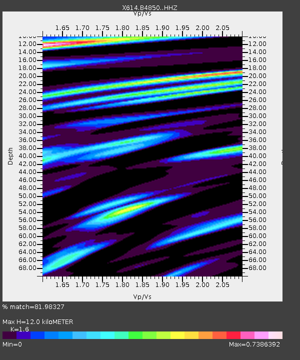
| Estimated Moho Depth: |
12.0 km |
| Estimated Crust Vp/Vs: |
1.60 |
| Assumed Crust Vp: |
6.242 km/s |
| Estimated Crust Vs: |
3.901 km/s |
| Estimated Crust Poisson's Ratio: |
0.18 |
|
| Radial Match: |
81.98327 % |
| Radial Bump: |
346 |
| Transverse Match: |
56.771946 % |
| Transverse Bump: |
263 |
| SOD ConfigId: |
11737051 |
| Insert Time: |
2019-04-25 03:18:31.524 +0000 |
| GWidth: |
2.5 |
| Max Bumps: |
400 |
| Tol: |
0.001 |
|

Signal To Noise
| Channel | StoN | STA | LTA |
| X6:B4850: :HHZ:20160723T01:10:14.809998Z | 11.397539 | 4.944063E-7 | 4.3378336E-8 |
| X6:B4850: :HHN:20160723T01:10:14.809998Z | 10.212243 | 2.3977302E-7 | 2.3478977E-8 |
| X6:B4850: :HHE:20160723T01:10:14.809998Z | 4.1224527 | 1.8549707E-7 | 4.4996774E-8 |
| Arrivals |
| Ps | 1.2 SECOND |
| PpPs | 4.8 SECOND |
| PsPs/PpSs | 6.0 SECOND |


