You are here: Home > Network List > US - United States National Seismic Network Stations List
> Station CBKS Cedar Bluff, Kansas, USA > Earthquake Result Viewer
CBKS Cedar Bluff, Kansas, USA - Earthquake Result Viewer

| Earthquake location: |
Kuril Islands |
| Earthquake latitude/longitude: |
47.5/154.2 |
| Earthquake time(UTC): |
2006/11/23 (327) 20:04:46 GMT |
| Earthquake Depth: |
10 km |
| Earthquake Magnitude: |
5.7 MB, 5.0 MS, 5.5 MW, 5.4 MW |
| Earthquake Catalog/Contributor: |
WHDF/NEIC |
|
| Network: |
US United States National Seismic Network |
| Station: |
CBKS Cedar Bluff, Kansas, USA |
| Lat/Lon: |
38.81 N/99.74 W |
| Elevation: |
677 m |
|
| Distance: |
71.8 deg |
| Az: |
52.218 deg |
| Baz: |
316.726 deg |
| Ray Param: |
0.054097094 |
| Estimated Moho Depth: |
10.0 km |
| Estimated Crust Vp/Vs: |
1.60 |
| Assumed Crust Vp: |
6.483 km/s |
| Estimated Crust Vs: |
4.052 km/s |
| Estimated Crust Poisson's Ratio: |
0.18 |
|
| Radial Match: |
99.90773 % |
| Radial Bump: |
13 |
| Transverse Match: |
99.344215 % |
| Transverse Bump: |
45 |
| SOD ConfigId: |
2564 |
| Insert Time: |
2010-03-05 05:31:30.612 +0000 |
| GWidth: |
2.5 |
| Max Bumps: |
400 |
| Tol: |
0.001 |
|
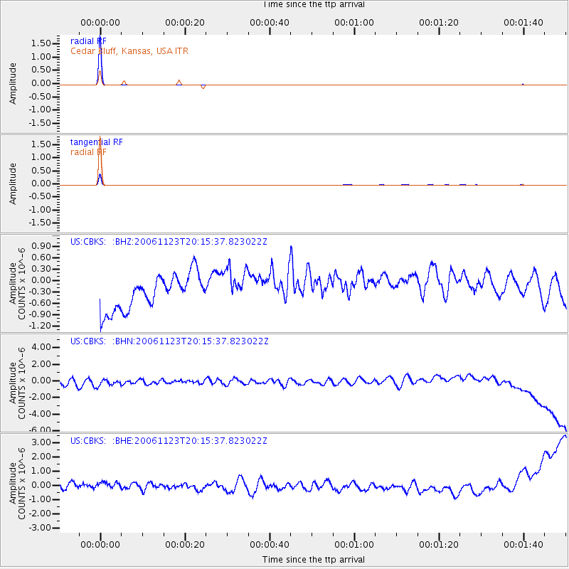
Signal To Noise
| Channel | StoN | STA | LTA |
| US:CBKS: :BHN:20061123T20:15:37.823022Z | 1.0251526 | 6.2131517E-7 | 6.0607096E-7 |
| US:CBKS: :BHE:20061123T20:15:37.823022Z | 1.0179045 | 4.163101E-7 | 4.0898735E-7 |
| US:CBKS: :BHZ:20061123T20:15:37.823022Z | 1.1187354 | 5.0111663E-7 | 4.4793134E-7 |
| Arrivals |
| Ps | 1.0 SECOND |
| PpPs | 3.9 SECOND |
| PsPs/PpSs | 4.8 SECOND |


