You are here: Home > Network List > US - United States National Seismic Network Stations List
> Station CBKS Cedar Bluff, Kansas, USA > Earthquake Result Viewer
CBKS Cedar Bluff, Kansas, USA - Earthquake Result Viewer

| Earthquake location: |
Kuril Islands |
| Earthquake latitude/longitude: |
44.2/146.8 |
| Earthquake time(UTC): |
2006/11/22 (326) 11:15:09 GMT |
| Earthquake Depth: |
80 km |
| Earthquake Magnitude: |
5.6 MB, 5.6 MW, 5.6 MW |
| Earthquake Catalog/Contributor: |
WHDF/NEIC |
|
| Network: |
US United States National Seismic Network |
| Station: |
CBKS Cedar Bluff, Kansas, USA |
| Lat/Lon: |
38.81 N/99.74 W |
| Elevation: |
677 m |
|
| Distance: |
77.9 deg |
| Az: |
47.12 deg |
| Baz: |
317.533 deg |
| Ray Param: |
0.049821913 |
| Estimated Moho Depth: |
10.0 km |
| Estimated Crust Vp/Vs: |
1.60 |
| Assumed Crust Vp: |
6.483 km/s |
| Estimated Crust Vs: |
4.052 km/s |
| Estimated Crust Poisson's Ratio: |
0.18 |
|
| Radial Match: |
99.88133 % |
| Radial Bump: |
9 |
| Transverse Match: |
99.343315 % |
| Transverse Bump: |
42 |
| SOD ConfigId: |
2564 |
| Insert Time: |
2010-03-05 05:31:33.324 +0000 |
| GWidth: |
2.5 |
| Max Bumps: |
400 |
| Tol: |
0.001 |
|
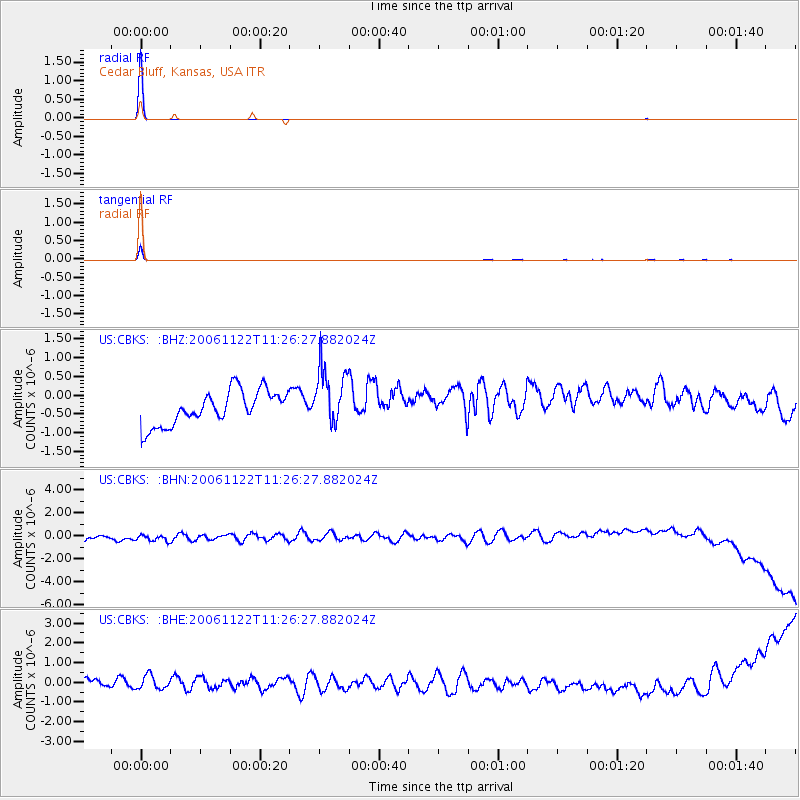
Signal To Noise
| Channel | StoN | STA | LTA |
| US:CBKS: :BHN:20061122T11:26:27.882024Z | 1.0684724 | 5.369617E-7 | 5.0255085E-7 |
| US:CBKS: :BHE:20061122T11:26:27.882024Z | 1.0989584 | 4.2175444E-7 | 3.8377652E-7 |
| US:CBKS: :BHZ:20061122T11:26:27.882024Z | 1.7312729 | 7.8122673E-7 | 4.5124412E-7 |
| Arrivals |
| Ps | 1.0 SECOND |
| PpPs | 3.9 SECOND |
| PsPs/PpSs | 4.8 SECOND |


