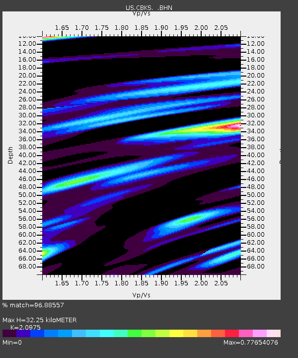
CBKS Cedar Bluff, Kansas, USA - Earthquake Result Viewer

Earthquake location: Fox Islands, Aleutian Islands
Earthquake latitude/longitude: 52.5/-169.3
Earthquake time(UTC): 2006/05/10 (130) 02:42:51 GMT
Earthquake Depth: 18 km
Earthquake Magnitude: 6.1 MB, 6.2 MS, 6.4 MW, 6.3 MW
Earthquake Catalog/Contributor: WHDF/NEIC
Network: US United States National Seismic Network
Station: CBKS Cedar Bluff, Kansas, USA
Lat/Lon: 38.81 N/99.74 W
Elevation: 677 m
Distance: 48.6 deg
Az: 77.286 deg
Baz: 310.264 deg
Ray Param: 0.06922495
Estimated Moho Depth: 32.25 km
Estimated Crust Vp/Vs: 2.10
Assumed Crust Vp: 6.483 km/s
Estimated Crust Vs: 3.091 km/s
Estimated Crust Poisson's Ratio: 0.35
Radial Match: 96.88557 %
Radial Bump: 400
Transverse Match: 80.979576 %
Transverse Bump: 400
SOD ConfigId: 2669
Insert Time: 2010-03-05 05:31:44.592 +0000
GWidth: 2.5
Max Bumps: 400
Tol: 0.001

Signal To Noise

ChannelStoNSTALTA
US:CBKS: :BHN:20060510T02:51:02.631013Z1.90991532.7081194E-71.4179264E-7
US:CBKS: :BHE:20060510T02:51:02.631013Z2.99073983.2265595E-71.0788499E-7
US:CBKS: :BHZ:20060510T02:51:02.631013Z8.6206758.658143E-71.0043463E-7
Arrivals
Ps5.7 SECOND
PpPs15 SECOND
PsPs/PpSs20 SECOND