You are here: Home > Network List > US - United States National Seismic Network Stations List
> Station CBKS Cedar Bluff, Kansas, USA > Earthquake Result Viewer
CBKS Cedar Bluff, Kansas, USA - Earthquake Result Viewer

| Earthquake location: |
Jujuy Province, Argentina |
| Earthquake latitude/longitude: |
-23.5/-66.5 |
| Earthquake time(UTC): |
2000/05/12 (133) 18:43:18 GMT |
| Earthquake Depth: |
225 km |
| Earthquake Magnitude: |
6.2 MB, 7.2 MW, 7.1 MW |
| Earthquake Catalog/Contributor: |
WHDF/NEIC |
|
| Network: |
US United States National Seismic Network |
| Station: |
CBKS Cedar Bluff, Kansas, USA |
| Lat/Lon: |
38.81 N/99.74 W |
| Elevation: |
677 m |
|
| Distance: |
69.4 deg |
| Az: |
332.745 deg |
| Baz: |
147.457 deg |
| Ray Param: |
0.055002347 |
| Estimated Moho Depth: |
41.5 km |
| Estimated Crust Vp/Vs: |
1.88 |
| Assumed Crust Vp: |
6.483 km/s |
| Estimated Crust Vs: |
3.457 km/s |
| Estimated Crust Poisson's Ratio: |
0.30 |
|
| Radial Match: |
97.87425 % |
| Radial Bump: |
273 |
| Transverse Match: |
92.21914 % |
| Transverse Bump: |
400 |
| SOD ConfigId: |
110165 |
| Insert Time: |
2010-03-05 05:32:27.323 +0000 |
| GWidth: |
2.5 |
| Max Bumps: |
400 |
| Tol: |
0.001 |
|
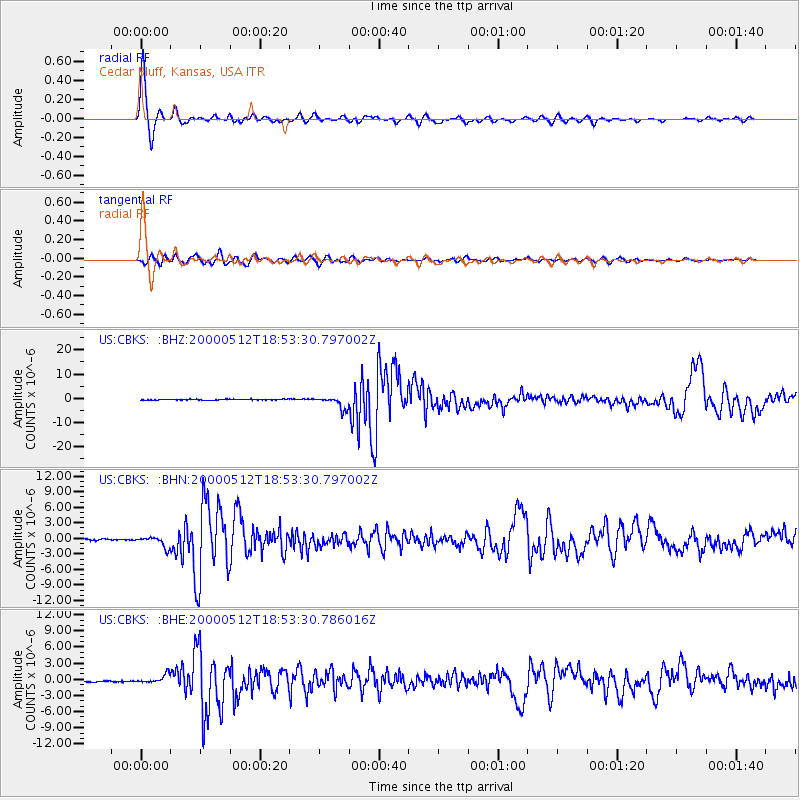
Signal To Noise
| Channel | StoN | STA | LTA |
| US:CBKS: :BHN:20000512T18:53:30.797002Z | 5.2434025 | 1.0039505E-6 | 1.9146927E-7 |
| US:CBKS: :BHE:20000512T18:53:30.786016Z | 3.8656204 | 7.539985E-7 | 1.950524E-7 |
| US:CBKS: :BHZ:20000512T18:53:30.797002Z | 14.035501 | 2.5749148E-6 | 1.8345729E-7 |
| Arrivals |
| Ps | 5.8 SECOND |
| PpPs | 18 SECOND |
| PsPs/PpSs | 24 SECOND |


